John Day River Commercial Post Use Report Form John Day River Blm


What is the John Day River Commercial Post Use Report Form?
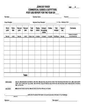
The John Day River Commercial Post Use Report Form is a document required by the Bureau of Land Management (BLM) for businesses operating along the John Day River. This form collects essential data on commercial activities, ensuring compliance with federal regulations and promoting responsible use of public lands. It is crucial for businesses involved in activities such as rafting, fishing, or other recreational services on the river.
How to Use the John Day River Commercial Post Use Report Form
Using the John Day River Commercial Post Use Report Form involves several steps. First, businesses must accurately fill out the form with details about their operations, including the type of services offered and the duration of use. It is important to provide precise information to avoid any compliance issues. Once completed, the form must be submitted to the appropriate BLM office for review and processing.
Steps to Complete the John Day River Commercial Post Use Report Form
Completing the John Day River Commercial Post Use Report Form requires careful attention to detail. Here are the steps to follow:
- Gather all necessary information about your commercial activities.
- Fill out the form, ensuring all sections are completed accurately.
- Review the form for any errors or omissions.
- Submit the completed form to the designated BLM office, either online or by mail.
Key Elements of the John Day River Commercial Post Use Report Form
The key elements of the John Day River Commercial Post Use Report Form include:
- Business name and contact information.
- Description of the commercial activities being conducted.
- Duration and frequency of use.
- Estimated number of participants or clients served.
- Compliance with environmental regulations.
Legal Use of the John Day River Commercial Post Use Report Form
The legal use of the John Day River Commercial Post Use Report Form is governed by federal regulations that aim to protect public lands and resources. Businesses must use this form to report their activities and ensure they are operating within the law. Failure to submit the form or provide accurate information can result in penalties, including fines or restrictions on future use of the river.
Form Submission Methods
The John Day River Commercial Post Use Report Form can be submitted through various methods. Businesses have the option to submit the form online via the BLM's designated portal, mail it to the appropriate BLM office, or deliver it in person. Each method has its own processing times, so it is advisable to choose the one that best fits the business's timeline.
Quick guide on how to complete john day river commercial post use report form john day river blm
Complete [SKS] effortlessly on any device
Digital document management has become increasingly popular among businesses and individuals alike. It serves as an ideal eco-friendly alternative to traditional printed and signed materials, allowing you to obtain the required forms and securely store them online. airSlate SignNow provides you with all the resources necessary to create, modify, and eSign your documents quickly without delays. Handle [SKS] on any device with airSlate SignNow’s Android or iOS applications and enhance any document-centric task today.
The simplest way to modify and eSign [SKS] with ease
- Locate [SKS] and click on Get Form to initiate.
- Utilize the tools we provide to complete your document.
- Highlight signNow sections of your documents or conceal confidential information with tools that airSlate SignNow offers specifically for that purpose.
- Generate your eSignature using the Sign feature, which takes only seconds and holds the same legal validity as a conventional wet ink signature.
- Review the information and click on the Done button to save your adjustments.
- Choose how you wish to share your form, via email, text message (SMS), invite link, or download it to your computer.
Eliminate concerns about lost or misplaced files, exhausting form searches, or mistakes that necessitate printing new document copies. airSlate SignNow fulfills all your document management requirements in just a few clicks from any device you prefer. Modify and eSign [SKS] to ensure outstanding communication at every step of the form preparation process with airSlate SignNow.
Create this form in 5 minutes or less
Related searches to John Day River Commercial Post Use Report Form John Day River Blm
Create this form in 5 minutes!
How to create an eSignature for the john day river commercial post use report form john day river blm
How to create an electronic signature for a PDF online
How to create an electronic signature for a PDF in Google Chrome
How to create an e-signature for signing PDFs in Gmail
How to create an e-signature right from your smartphone
How to create an e-signature for a PDF on iOS
How to create an e-signature for a PDF on Android
People also ask
-
What is the John Day River Commercial Post Use Report Form John Day River BLM?
The John Day River Commercial Post Use Report Form John Day River BLM is a document required for businesses operating in the John Day River area. It helps ensure compliance with Bureau of Land Management regulations by documenting commercial activities. This form is essential for maintaining transparency and accountability in river use.
-
How can airSlate SignNow help with the John Day River Commercial Post Use Report Form John Day River BLM?
airSlate SignNow streamlines the process of completing and submitting the John Day River Commercial Post Use Report Form John Day River BLM. Our platform allows users to easily fill out, eSign, and send the form electronically, saving time and reducing paperwork. This ensures that your submissions are accurate and timely.
-
Is there a cost associated with using airSlate SignNow for the John Day River Commercial Post Use Report Form John Day River BLM?
Yes, airSlate SignNow offers various pricing plans to accommodate different business needs. Our plans are designed to be cost-effective while providing all the necessary features for managing documents like the John Day River Commercial Post Use Report Form John Day River BLM. You can choose a plan that fits your budget and requirements.
-
What features does airSlate SignNow offer for the John Day River Commercial Post Use Report Form John Day River BLM?
airSlate SignNow provides features such as customizable templates, eSignature capabilities, and secure document storage for the John Day River Commercial Post Use Report Form John Day River BLM. These features enhance the efficiency of document management and ensure compliance with BLM regulations. Additionally, our platform is user-friendly, making it easy for anyone to navigate.
-
Can I integrate airSlate SignNow with other tools for the John Day River Commercial Post Use Report Form John Day River BLM?
Absolutely! airSlate SignNow offers integrations with various applications, allowing you to streamline your workflow when handling the John Day River Commercial Post Use Report Form John Day River BLM. Whether you use CRM systems, cloud storage, or project management tools, our platform can connect seamlessly to enhance your document management process.
-
What are the benefits of using airSlate SignNow for the John Day River Commercial Post Use Report Form John Day River BLM?
Using airSlate SignNow for the John Day River Commercial Post Use Report Form John Day River BLM provides numerous benefits, including increased efficiency, reduced errors, and improved compliance. Our platform simplifies the document signing process, allowing you to focus on your business operations. Additionally, the electronic submission helps you meet deadlines effortlessly.
-
Is airSlate SignNow secure for handling the John Day River Commercial Post Use Report Form John Day River BLM?
Yes, airSlate SignNow prioritizes security and compliance when handling documents like the John Day River Commercial Post Use Report Form John Day River BLM. We utilize advanced encryption and security protocols to protect your data. You can trust that your sensitive information is safe while using our platform.
Get more for John Day River Commercial Post Use Report Form John Day River Blm
- Arizona board of pharmacy character voucher form
- Dog training class registration form consent and
- Food pantry intake form 77118972
- Tennessee bureau of investigationtoris 901 r s gass form
- Adrenal crisis action plan plano independent school district pisd form
- Soil evaluation report form
- Cat adoption questionnaire 77437279 form
- Cat adoption questionnaire 777142944 form
Find out other John Day River Commercial Post Use Report Form John Day River Blm
- Electronic signature Connecticut Award Nomination Form Fast
- eSignature South Dakota Apartment lease agreement template Free
- eSignature Maine Business purchase agreement Simple
- eSignature Arizona Generic lease agreement Free
- eSignature Illinois House rental agreement Free
- How To eSignature Indiana House rental agreement
- Can I eSignature Minnesota House rental lease agreement
- eSignature Missouri Landlord lease agreement Fast
- eSignature Utah Landlord lease agreement Simple
- eSignature West Virginia Landlord lease agreement Easy
- How Do I eSignature Idaho Landlord tenant lease agreement
- eSignature Washington Landlord tenant lease agreement Free
- eSignature Wisconsin Landlord tenant lease agreement Online
- eSignature Wyoming Landlord tenant lease agreement Online
- How Can I eSignature Oregon lease agreement
- eSignature Washington Lease agreement form Easy
- eSignature Alaska Lease agreement template Online
- eSignature Alaska Lease agreement template Later
- eSignature Massachusetts Lease agreement template Myself
- Can I eSignature Arizona Loan agreement