Gis Metadata Template Form


What is the GIS Metadata Template
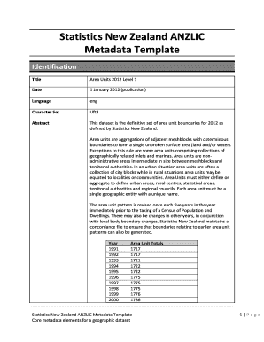
The GIS metadata template is a structured document designed to capture essential information about geographic data sets. This template serves as a standardized format to ensure that users can easily understand the context, quality, and characteristics of the data. It typically includes details such as the data source, date of creation, data quality, spatial reference, and any applicable restrictions or usage rights. By utilizing this template, organizations can enhance data sharing and interoperability, making it easier for stakeholders to access and utilize geographic information effectively.
How to Use the GIS Metadata Template
Using the GIS metadata template involves several straightforward steps. Begin by gathering all relevant information about the geographic data set you wish to document. This includes details on the data's origin, its intended use, and any limitations. Next, fill in the template fields with accurate and comprehensive information. Ensure that you adhere to any specific formatting guidelines provided within the template. Once completed, save the document in a secure format, such as PDF or XML, to maintain its integrity. Sharing the completed metadata template with stakeholders facilitates better understanding and utilization of the geographic data.
Steps to Complete the GIS Metadata Template
Completing the GIS metadata template requires careful attention to detail. Follow these steps for effective completion:
- Gather all necessary data about the geographic data set.
- Fill in the template fields, including data title, abstract, and keywords.
- Document the data source and any relevant citations.
- Include information on data quality, such as accuracy and completeness.
- Specify the spatial reference system used in the data set.
- Review the completed template for accuracy and completeness.
- Save and distribute the template as needed.
Key Elements of the GIS Metadata Template
Several key elements are essential to include in the GIS metadata template to ensure comprehensive documentation. These elements typically consist of:
- Title: A clear and descriptive title for the data set.
- Abstract: A brief summary of the data set's purpose and content.
- Keywords: Relevant terms that aid in data discovery.
- Data Source: Information on where the data originated.
- Data Quality: Assessment of the data's accuracy and reliability.
- Spatial Reference: Details about the coordinate system used.
- Access and Use Constraints: Any restrictions on data usage.
Legal Use of the GIS Metadata Template
When utilizing the GIS metadata template, it is crucial to ensure compliance with applicable laws and regulations. This includes adhering to copyright laws regarding data ownership and usage rights. Organizations should also consider privacy regulations when documenting sensitive geographic data. By following legal guidelines, users can mitigate risks associated with data sharing and ensure that the metadata template serves its intended purpose without infringing on any rights.
Examples of Using the GIS Metadata Template
Practical applications of the GIS metadata template can be observed across various sectors. For instance:
- A city government may use the template to document zoning data for public access.
- A research institution could employ it to catalog environmental data collected during field studies.
- A utility company might utilize the template to maintain records of infrastructure data for maintenance and planning purposes.
These examples illustrate how the GIS metadata template facilitates better data management and enhances the usability of geographic information across different fields.
Quick guide on how to complete gis metadata template
Effortlessly Prepare Gis Metadata Template on Any Device
Digital document management has gained traction among businesses and individuals alike. It offers a perfect environmentally friendly substitute for conventional printed and signed paperwork, as you can easily find the right form and securely keep it online. airSlate SignNow provides you with all the tools you need to design, modify, and electronically sign your documents swiftly without delays. Handle Gis Metadata Template on any platform using airSlate SignNow's Android or iOS applications and enhance any document-related task today.
How to Alter and Electronically Sign Gis Metadata Template with Ease
- Find Gis Metadata Template and then click Get Form to begin.
- Utilize the tools we offer to complete your form.
- Emphasize pertinent sections of your documents or obscure sensitive information with tools specifically provided by airSlate SignNow for that purpose.
- Generate your electronic signature with the Sign feature, which takes a matter of seconds and carries the same legal validity as a traditional handwritten signature.
- Review all the information and then click on the Done button to save your modifications.
- Choose how you wish to share your form, through email, SMS, or a link invitation, or download it to your computer.
Eliminate concerns about lost or misplaced documents, tedious form searching, or errors that necessitate printing new document copies. airSlate SignNow meets your needs in document management in just a few clicks from any preferred device. Modify and electronically sign Gis Metadata Template to ensure effective communication at every step of your form preparation process with airSlate SignNow.
Create this form in 5 minutes or less
Create this form in 5 minutes!
How to create an eSignature for the gis metadata template
How to create an electronic signature for a PDF online
How to create an electronic signature for a PDF in Google Chrome
How to create an e-signature for signing PDFs in Gmail
How to create an e-signature right from your smartphone
How to create an e-signature for a PDF on iOS
How to create an e-signature for a PDF on Android
People also ask
-
What is a GIS metadata template?
A GIS metadata template is a structured format designed to standardize the documentation of geographic information. It helps organizations maintain consistent metadata across various geospatial datasets, ensuring improved data usability and sharing.
-
How can I create a GIS metadata template using airSlate SignNow?
You can create a GIS metadata template in airSlate SignNow by using our document generation features. Simply choose a customizable template, input your metadata requirements, and streamline your workflow to ensure all necessary information is included.
-
What are the benefits of using a GIS metadata template?
Using a GIS metadata template allows for improved data quality, accessibility, and compliance with industry standards. This ensures that all stakeholders can understand and effectively utilize geographic data, leading to more informed decision-making.
-
Is airSlate SignNow's GIS metadata template customizable?
Yes, airSlate SignNow provides fully customizable GIS metadata templates. You can tailor these templates to fit your specific organizational needs, ensuring they capture all essential data points relevant to your projects.
-
Can I integrate airSlate SignNow with other platforms to manage GIS metadata templates?
Absolutely! airSlate SignNow offers seamless integrations with various platforms, allowing you to manage GIS metadata templates alongside your existing tools. This integration enhances your workflow, making it easier to share and update metadata consistently.
-
What pricing options are available for using GIS metadata templates with airSlate SignNow?
airSlate SignNow offers competitive pricing plans that cater to businesses of all sizes. Depending on your needs, you can choose a plan that provides extensive features for managing GIS metadata templates without breaking the bank.
-
Can I collaborate with team members on GIS metadata templates in airSlate SignNow?
Yes, collaboration is a key feature in airSlate SignNow. You can invite team members to view, edit, or comment on your GIS metadata templates in real-time, fostering effective teamwork and ensuring your datasets are well-documented.
Get more for Gis Metadata Template
Find out other Gis Metadata Template
- eSign Missouri Real Estate Affidavit Of Heirship Simple
- eSign New Jersey Real Estate Limited Power Of Attorney Later
- eSign Alabama Police LLC Operating Agreement Fast
- eSign North Dakota Real Estate Business Letter Template Computer
- eSign North Dakota Real Estate Quitclaim Deed Myself
- eSign Maine Sports Quitclaim Deed Easy
- eSign Ohio Real Estate LLC Operating Agreement Now
- eSign Ohio Real Estate Promissory Note Template Online
- How To eSign Ohio Real Estate Residential Lease Agreement
- Help Me With eSign Arkansas Police Cease And Desist Letter
- How Can I eSign Rhode Island Real Estate Rental Lease Agreement
- How Do I eSign California Police Living Will
- Can I eSign South Dakota Real Estate Quitclaim Deed
- How To eSign Tennessee Real Estate Business Associate Agreement
- eSign Michigan Sports Cease And Desist Letter Free
- How To eSign Wisconsin Real Estate Contract
- How To eSign West Virginia Real Estate Quitclaim Deed
- eSign Hawaii Police Permission Slip Online
- eSign New Hampshire Sports IOU Safe
- eSign Delaware Courts Operating Agreement Easy