Latitude and Longitude Grid Scott Foresman Social Studies Form


What is the Latitude And Longitude Grid Scott Foresman Social Studies
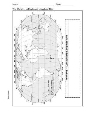
The Latitude and Longitude Grid Scott Foresman Social Studies is an educational tool used to teach students about geographic coordinates. This grid provides a visual representation of how latitude and longitude lines intersect to form a coordinate system that helps in locating places on Earth. The grid is particularly useful in social studies, as it aids in understanding global geography, navigation, and map reading skills. By learning to use this grid, students can better grasp the significance of geographic locations and their relation to various cultural and historical contexts.
How to use the Latitude And Longitude Grid Scott Foresman Social Studies
Using the Latitude and Longitude Grid involves several steps that enhance students' understanding of geographic concepts. First, students should familiarize themselves with the grid's layout, noting the horizontal lines representing latitude and the vertical lines representing longitude. Next, they can practice locating specific coordinates by identifying the intersection points on the grid. Teachers can incorporate exercises that require students to find various cities or landmarks based on given coordinates, enhancing their spatial awareness and map skills.
Steps to complete the Latitude And Longitude Grid Scott Foresman Social Studies
Completing the Latitude and Longitude Grid involves a systematic approach. Begin by selecting a specific location or coordinate. Then, identify the corresponding latitude and longitude values. Mark these values on the grid accurately. Students should practice by completing multiple examples, reinforcing their understanding of how to read and interpret geographic coordinates. Additionally, incorporating discussions about the importance of these coordinates in real-world applications, such as navigation and global positioning, can deepen their learning experience.
Key elements of the Latitude And Longitude Grid Scott Foresman Social Studies
Several key elements define the Latitude and Longitude Grid. These include the equator, which serves as the zero-degree latitude line, and the prime meridian, which is the zero-degree longitude line. The grid is divided into degrees, with each degree further subdivided into minutes and seconds, allowing for precise location identification. Understanding these elements is crucial for students as they learn how to navigate and interpret maps effectively. Additionally, recognizing the significance of hemispheres and how they affect climate and culture can enrich their geographical knowledge.
Legal use of the Latitude And Longitude Grid Scott Foresman Social Studies
The legal use of the Latitude and Longitude Grid in educational settings is primarily focused on its role in teaching geography and social studies. While the grid itself does not have legal implications, the skills acquired through its use can be applied in various fields, including environmental science, urban planning, and navigation. Educators should ensure that the grid is used in compliance with educational standards and guidelines, promoting a comprehensive understanding of geography among students.
Examples of using the Latitude And Longitude Grid Scott Foresman Social Studies
Examples of using the Latitude and Longitude Grid include classroom activities where students locate major cities, landmarks, or geographical features based on given coordinates. For instance, a teacher might ask students to find the coordinates for the Statue of Liberty in New York City or the Eiffel Tower in Paris. Another example is using the grid to explore historical trade routes or migration patterns, allowing students to connect geographic knowledge with historical events. These practical applications help solidify students' understanding of the grid's relevance in real-world contexts.
Quick guide on how to complete latitude and longitude grid scott foresman social studies
Complete Latitude And Longitude Grid Scott Foresman Social Studies effortlessly on any device
Online document administration has gained traction among businesses and individuals. It offers an ideal eco-friendly substitute for conventional printed and signed paperwork, allowing you to locate the right form and securely store it online. airSlate SignNow provides you with all the tools required to create, modify, and electronically sign your documents swiftly without delays. Manage Latitude And Longitude Grid Scott Foresman Social Studies on any device with airSlate SignNow's Android or iOS applications and simplify any document-related task today.
The easiest way to modify and electronically sign Latitude And Longitude Grid Scott Foresman Social Studies without hassle
- Find Latitude And Longitude Grid Scott Foresman Social Studies and then click Get Form to commence.
- Utilize the tools we provide to finalize your document.
- Emphasize pertinent sections of the documents or redact confidential information with tools that airSlate SignNow offers specifically for that purpose.
- Create your electronic signature using the Sign tool, which takes moments and carries the same legal validity as a traditional handwritten signature.
- Review all the details and then click on the Done button to save your modifications.
- Choose how you wish to deliver your form, via email, SMS, or invite link, or download it to your computer.
Eliminate worries about lost or misplaced documents, tedious form hunting, or errors that necessitate printing new document copies. airSlate SignNow meets your requirements in document management in just a few clicks from any device of your preference. Modify and electronically sign Latitude And Longitude Grid Scott Foresman Social Studies to ensure exceptional communication at every stage of the form preparation process with airSlate SignNow.
Create this form in 5 minutes or less
Create this form in 5 minutes!
How to create an eSignature for the latitude and longitude grid scott foresman social studies
How to create an electronic signature for a PDF online
How to create an electronic signature for a PDF in Google Chrome
How to create an e-signature for signing PDFs in Gmail
How to create an e-signature right from your smartphone
How to create an e-signature for a PDF on iOS
How to create an e-signature for a PDF on Android
People also ask
-
What is the Latitude And Longitude Grid Scott Foresman Social Studies?
The Latitude And Longitude Grid Scott Foresman Social Studies is a tool designed to help students understand geographical coordinates and map reading skills. It provides a structured way to interpret latitude and longitude, aiding in the learning process of social studies. This grid can enhance students' ability to navigate the world around them.
-
How can I integrate the Latitude And Longitude Grid Scott Foresman Social Studies into my classroom?
Integrating the Latitude And Longitude Grid Scott Foresman Social Studies into your classroom can be easily accomplished with various teaching resources. You can utilize interactive activities or worksheets that feature the grid, encouraging students to practice using latitude and longitude. This integration fosters engagement and hands-on learning experiences.
-
What are the benefits of using the Latitude And Longitude Grid Scott Foresman Social Studies in education?
Using the Latitude And Longitude Grid Scott Foresman Social Studies helps students develop critical geographic skills. By learning how to read coordinates, they gain a better understanding of maps and global positioning. This foundational knowledge is essential for many subjects within social studies and beyond.
-
Is the Latitude And Longitude Grid Scott Foresman Social Studies affordable for schools?
Yes, the Latitude And Longitude Grid Scott Foresman Social Studies is offered at a competitive price, making it an accessible resource for schools. Many educational institutions find that the value it adds to their curriculum justifies the cost. Discounts may also be available for bulk purchases.
-
Can the Latitude And Longitude Grid Scott Foresman Social Studies be used in remote learning environments?
Absolutely, the Latitude And Longitude Grid Scott Foresman Social Studies is adaptable for both in-person and remote learning settings. Teachers can share digital resources, such as interactive grids or online exercises, enabling students to learn effectively even from home. This flexibility ensures continued education regardless of learning circumstances.
-
What features are included in the Latitude And Longitude Grid Scott Foresman Social Studies?
The Latitude And Longitude Grid Scott Foresman Social Studies includes user-friendly grids and resources that simplify concepts of geography. Features like detailed explanations, visual aids, and practice exercises help students grasp the material quickly. These thoughtfully designed features cater to diverse learning styles.
-
How does the Latitude And Longitude Grid Scott Foresman Social Studies support teachers?
The Latitude And Longitude Grid Scott Foresman Social Studies supports teachers by providing a structured framework for instruction. It equips educators with comprehensive materials that can be easily integrated into lessons. This support ultimately enhances teaching efficiency and student understanding.
Get more for Latitude And Longitude Grid Scott Foresman Social Studies
Find out other Latitude And Longitude Grid Scott Foresman Social Studies
- How Can I eSign Connecticut Lawers Presentation
- Help Me With eSign Hawaii Lawers Word
- How Can I eSign Hawaii Lawers Document
- How To eSign Hawaii Lawers PPT
- Help Me With eSign Hawaii Insurance PPT
- Help Me With eSign Idaho Insurance Presentation
- Can I eSign Indiana Insurance Form
- How To eSign Maryland Insurance PPT
- Can I eSign Arkansas Life Sciences PDF
- How Can I eSign Arkansas Life Sciences PDF
- Can I eSign Connecticut Legal Form
- How Do I eSign Connecticut Legal Form
- How Do I eSign Hawaii Life Sciences Word
- Can I eSign Hawaii Life Sciences Word
- How Do I eSign Hawaii Life Sciences Document
- How Do I eSign North Carolina Insurance Document
- How Can I eSign Hawaii Legal Word
- Help Me With eSign Hawaii Legal Document
- How To eSign Hawaii Legal Form
- Help Me With eSign Hawaii Legal Form