Local Regulatory Floodplain Lrf Elevation Certificate MSD Msdlouky 2007-2026


What is the Local Regulatory Floodplain LRF Elevation Certificate?
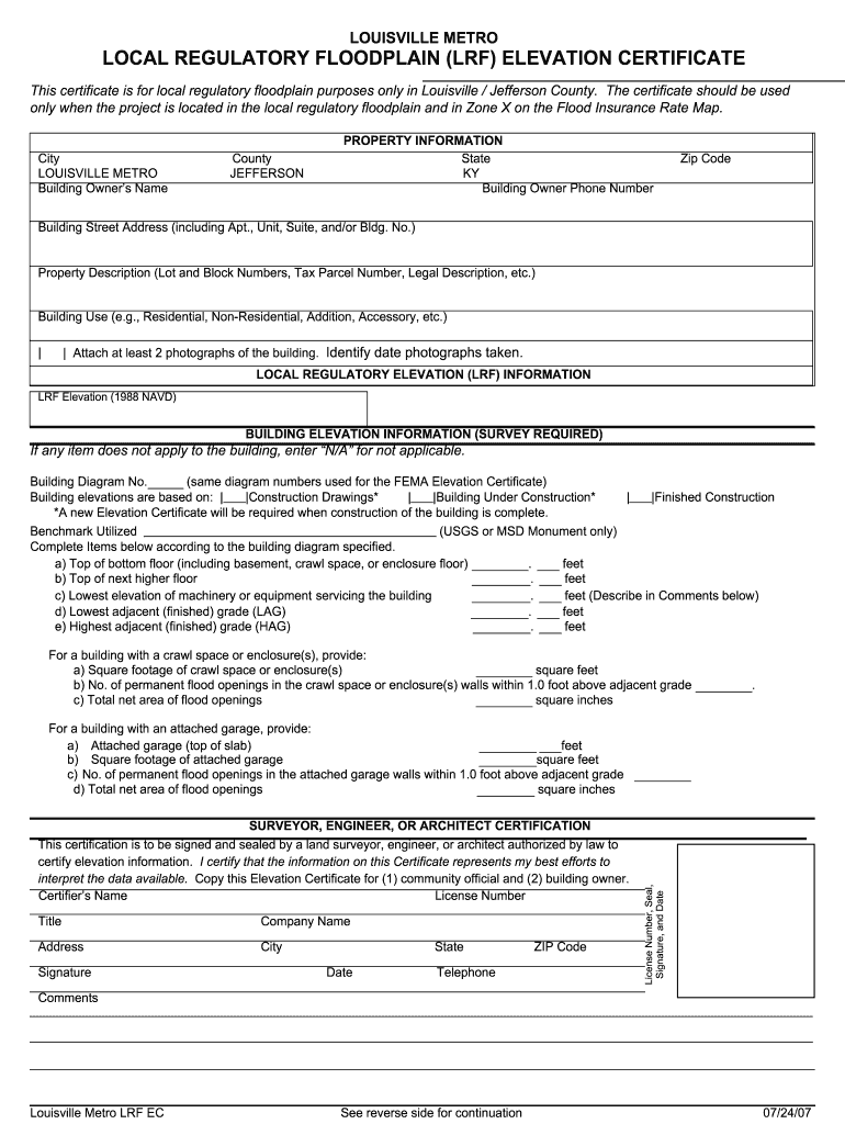
The Local Regulatory Floodplain LRF Elevation Certificate is a crucial document used to determine the elevation of a property in relation to the base flood elevation in flood-prone areas. This certificate is essential for compliance with local floodplain management regulations and is often required by insurance companies to assess flood insurance premiums. The LRF Elevation Certificate provides detailed information about the property's elevation, which helps in evaluating the risk of flooding and ensuring that the property meets local zoning and building requirements.
How to Obtain the Local Regulatory Floodplain LRF Elevation Certificate
To obtain the Local Regulatory Floodplain LRF Elevation Certificate, property owners typically need to follow a specific process. First, they must contact their local floodplain management office or building department to request the certificate. Depending on the jurisdiction, the process may involve submitting a completed application form along with any required documentation, such as property surveys or elevation data. It is advisable to check with local authorities for any specific requirements or fees associated with obtaining the certificate.
Steps to Complete the Local Regulatory Floodplain LRF Elevation Certificate
Completing the Local Regulatory Floodplain LRF Elevation Certificate involves several key steps:
- Gather necessary information about the property, including its location, legal description, and existing elevation data.
- Consult with a qualified surveyor or engineer to obtain accurate elevation measurements, if needed.
- Fill out the elevation certificate form, ensuring all sections are completed accurately, including the flood zone designation and building characteristics.
- Submit the completed certificate to the appropriate local authority for review and approval.
Key Elements of the Local Regulatory Floodplain LRF Elevation Certificate
The Local Regulatory Floodplain LRF Elevation Certificate contains several important elements that must be accurately documented. These include:
- The property's location and legal description.
- The elevation of the lowest floor of the building, including any attached garages.
- The base flood elevation as determined by local floodplain maps.
- Information about the flood zone designation.
- Signatures from the property owner and the surveyor or engineer who completed the certificate.
Legal Use of the Local Regulatory Floodplain LRF Elevation Certificate
The Local Regulatory Floodplain LRF Elevation Certificate serves a legal purpose in floodplain management and insurance. It is used to determine compliance with local regulations and to establish eligibility for flood insurance under the National Flood Insurance Program (NFIP). Properly completed certificates are legally binding documents that can be used in disputes regarding flood risk and insurance claims. It is essential for property owners to ensure that the certificate is filled out accurately to avoid potential legal issues.
Examples of Using the Local Regulatory Floodplain LRF Elevation Certificate
There are various scenarios where the Local Regulatory Floodplain LRF Elevation Certificate is utilized:
- When purchasing or selling a property in a flood-prone area, the certificate may be required to assess flood risk.
- Homeowners seeking flood insurance must provide the certificate to determine coverage and premiums.
- Local governments may require the certificate for building permits or renovations in flood zones.
Quick guide on how to complete local regulatory floodplain lrf elevation certificate msd msdlouky
Prepare Local Regulatory Floodplain lrf Elevation Certificate MSD Msdlouky effortlessly on any device
Online document organization has become increasingly favored by businesses and individuals alike. It serves as an ideal eco-friendly alternative to conventional printed and signed paperwork, allowing you to access the necessary form and securely store it online. airSlate SignNow equips you with all the resources required to create, modify, and electronically sign your documents swiftly without delays. Handle Local Regulatory Floodplain lrf Elevation Certificate MSD Msdlouky on any platform with airSlate SignNow's Android or iOS applications and enhance any document-driven process today.
The easiest way to modify and eSign Local Regulatory Floodplain lrf Elevation Certificate MSD Msdlouky without fuss
- Find Local Regulatory Floodplain lrf Elevation Certificate MSD Msdlouky and click on Get Form to begin.
- Utilize the tools we offer to complete your form.
- Emphasize pertinent sections of the documents or black out sensitive information with tools specifically offered by airSlate SignNow for that purpose.
- Create your signature using the Sign tool, which takes mere seconds and carries the same legal validity as a traditional wet ink signature.
- Review the details and then click the Done button to save your changes.
- Choose how you want to submit your form, via email, SMS, or invitation link, or download it to your computer.
Forget about lost or misplaced documents, tedious form searching, or errors that require reprinting new document copies. airSlate SignNow addresses your document management needs in just a few clicks from any device you prefer. Modify and eSign Local Regulatory Floodplain lrf Elevation Certificate MSD Msdlouky and ensure excellent communication at every stage of the form preparation process with airSlate SignNow.
Create this form in 5 minutes or less
Create this form in 5 minutes!
How to create an eSignature for the local regulatory floodplain lrf elevation certificate msd msdlouky
How to generate an electronic signature for your Local Regulatory Floodplain Lrf Elevation Certificate Msd Msdlouky in the online mode
How to make an eSignature for the Local Regulatory Floodplain Lrf Elevation Certificate Msd Msdlouky in Chrome
How to generate an eSignature for putting it on the Local Regulatory Floodplain Lrf Elevation Certificate Msd Msdlouky in Gmail
How to create an electronic signature for the Local Regulatory Floodplain Lrf Elevation Certificate Msd Msdlouky right from your mobile device
How to generate an electronic signature for the Local Regulatory Floodplain Lrf Elevation Certificate Msd Msdlouky on iOS
How to generate an electronic signature for the Local Regulatory Floodplain Lrf Elevation Certificate Msd Msdlouky on Android OS
People also ask
-
What is a Local Regulatory Floodplain lrf Elevation Certificate MSD Msdlouky?
A Local Regulatory Floodplain lrf Elevation Certificate MSD Msdlouky is an essential document used to determine the elevation of a property in relation to floodplain management regulations. This certificate is crucial for assessing flood risks and is often required for obtaining flood insurance. Having this certificate ensures compliance with local regulations and helps protect your investment.
-
How much does a Local Regulatory Floodplain lrf Elevation Certificate MSD Msdlouky cost?
The cost of obtaining a Local Regulatory Floodplain lrf Elevation Certificate MSD Msdlouky can vary based on factors such as location and the complexity of the property. Typically, prices range from $200 to $500, depending on the surveying company and specific requirements. It's advisable to request quotes from certified professionals to find the best pricing.
-
What features does airSlate SignNow offer for handling Local Regulatory Floodplain lrf Elevation Certificates MSD Msdlouky?
airSlate SignNow provides an intuitive platform that allows users to easily send, eSign, and manage Local Regulatory Floodplain lrf Elevation Certificates MSD Msdlouky. With customizable templates and secure cloud storage, users can efficiently track document statuses and ensure compliance with regulatory requirements. The platform is designed to streamline the entire process, saving you time and effort.
-
How can airSlate SignNow help with document compliance for Local Regulatory Floodplain lrf Elevation Certificates MSD Msdlouky?
airSlate SignNow ensures that your Local Regulatory Floodplain lrf Elevation Certificates MSD Msdlouky meet compliance standards by providing secure eSigning and document management features. The platform keeps all documents organized and easily accessible, allowing for quick retrieval and review. Additionally, our solution helps maintain a clear audit trail for compliance verification.
-
Can I integrate airSlate SignNow with other tools for managing Local Regulatory Floodplain lrf Elevation Certificates MSD Msdlouky?
Yes, airSlate SignNow offers seamless integrations with various software applications commonly used in real estate and property management. These integrations allow you to streamline your workflow when dealing with Local Regulatory Floodplain lrf Elevation Certificates MSD Msdlouky. By connecting with tools like CRM systems and project management software, you can enhance productivity and ensure all relevant data is synchronized.
-
What are the benefits of using airSlate SignNow for Local Regulatory Floodplain lrf Elevation Certificates MSD Msdlouky?
Using airSlate SignNow for Local Regulatory Floodplain lrf Elevation Certificates MSD Msdlouky offers numerous benefits, including time-saving document processing, reduced paperwork, and enhanced security for sensitive information. Our user-friendly platform simplifies the signing process, ensuring that all stakeholders can easily participate. Additionally, our cost-effective solution helps businesses manage their documentation more efficiently.
-
Is airSlate SignNow secure for processing Local Regulatory Floodplain lrf Elevation Certificates MSD Msdlouky?
Absolutely! airSlate SignNow employs state-of-the-art security measures to protect your documents, including Local Regulatory Floodplain lrf Elevation Certificates MSD Msdlouky. Our platform utilizes encryption, secure access controls, and regular security audits to ensure that your data remains confidential and protected from unauthorized access. You can trust us to keep your important documents safe.
Get more for Local Regulatory Floodplain lrf Elevation Certificate MSD Msdlouky
- Electrical contractor package idaho form
- Sheetrock drywall contractor package idaho form
- Flooring contractor package idaho form
- Trim carpentry contractor package idaho form
- Fencing contractor package idaho form
- Hvac contractor package idaho form
- Landscaping contractor package idaho form
- Commercial contractor package idaho form
Find out other Local Regulatory Floodplain lrf Elevation Certificate MSD Msdlouky
- Electronic signature Michigan Email Cover Letter Template Free
- Electronic signature Delaware Termination Letter Template Now
- How Can I Electronic signature Washington Employee Performance Review Template
- Electronic signature Florida Independent Contractor Agreement Template Now
- Electronic signature Michigan Independent Contractor Agreement Template Now
- Electronic signature Oregon Independent Contractor Agreement Template Computer
- Electronic signature Texas Independent Contractor Agreement Template Later
- Electronic signature Florida Employee Referral Form Secure
- How To Electronic signature Florida CV Form Template
- Electronic signature Mississippi CV Form Template Easy
- Electronic signature Ohio CV Form Template Safe
- Electronic signature Nevada Employee Reference Request Mobile
- How To Electronic signature Washington Employee Reference Request
- Electronic signature New York Working Time Control Form Easy
- How To Electronic signature Kansas Software Development Proposal Template
- Electronic signature Utah Mobile App Design Proposal Template Fast
- Electronic signature Nevada Software Development Agreement Template Free
- Electronic signature New York Operating Agreement Safe
- How To eSignature Indiana Reseller Agreement
- Electronic signature Delaware Joint Venture Agreement Template Free