GPS Observation Log Sheet FAA Airports GIS Program Federal Form


What is the GPS Observation Log Sheet FAA Airports GIS Program Federal?
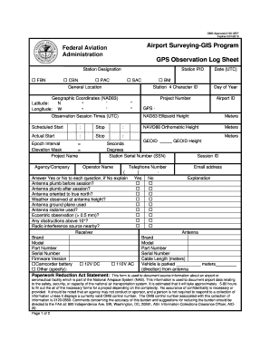
The GPS Observation Log Sheet is a vital document used in the FAA Airports GIS Program, designed to record and manage geospatial data related to airport operations. This form ensures that accurate GPS observations are documented, facilitating compliance with federal regulations and enhancing the overall safety and efficiency of airport management. It serves as an essential tool for airport authorities, engineers, and planners to maintain up-to-date records of airport layouts, navigational aids, and other critical infrastructure.
How to use the GPS Observation Log Sheet FAA Airports GIS Program Federal
Using the GPS Observation Log Sheet involves a structured approach to ensure that all necessary data is captured accurately. First, gather the required equipment, including a GPS device and any supplementary tools needed for data collection. Next, follow the established procedures for recording observations, which typically include noting the location, date, time, and specific GPS coordinates. After completing the data collection, ensure that the log sheet is filled out comprehensively, with all fields completed to meet FAA standards. Finally, submit the completed log sheet to the appropriate authorities for review and compliance verification.
Steps to complete the GPS Observation Log Sheet FAA Airports GIS Program Federal
Completing the GPS Observation Log Sheet requires attention to detail and adherence to specific steps:
- Prepare your GPS device and ensure it is calibrated correctly.
- Identify the observation points you need to document, including any relevant landmarks or infrastructure.
- Record the GPS coordinates for each observation point, along with the corresponding date and time.
- Fill in the log sheet, ensuring all required fields are completed accurately.
- Review the completed log sheet for any errors or omissions before submission.
Key elements of the GPS Observation Log Sheet FAA Airports GIS Program Federal
The GPS Observation Log Sheet includes several key elements that are essential for accurate data recording. These elements typically consist of:
- Date and Time: The specific date and time when the observation was made.
- GPS Coordinates: The latitude and longitude of the observation point.
- Observation Details: Any relevant notes about the conditions or context of the observation.
- Signature: The signature of the individual completing the log sheet, confirming the accuracy of the information provided.
Legal use of the GPS Observation Log Sheet FAA Airports GIS Program Federal
The GPS Observation Log Sheet is legally binding when completed in accordance with federal regulations. To ensure its legal validity, it must be filled out accurately and submitted to the appropriate regulatory bodies. Compliance with relevant laws, such as the ESIGN Act and UETA, is crucial for the electronic submission of this document. Additionally, maintaining a secure and verifiable process for signing and storing this log sheet enhances its legal standing, making it an essential component of airport operations.
How to obtain the GPS Observation Log Sheet FAA Airports GIS Program Federal
Obtaining the GPS Observation Log Sheet is a straightforward process. Typically, airport authorities or relevant federal agencies provide access to the form through official channels. Interested parties can usually download the log sheet from the FAA's website or request a physical copy from their local airport authority. Ensuring that you have the most current version of the log sheet is important to comply with any updates or changes in regulations.
Quick guide on how to complete gps observation log sheet faa airports gis program federal
Effortlessly prepare GPS Observation Log Sheet FAA Airports GIS Program Federal on any device
Managing documents online has become increasingly popular among businesses and individuals alike. It serves as an ideal eco-friendly substitute for traditional printed and signed documentation, allowing you to access the necessary forms and securely store them online. airSlate SignNow equips you with all the tools you need to create, modify, and electronically sign your documents swiftly without delays. Manage GPS Observation Log Sheet FAA Airports GIS Program Federal on any platform with airSlate SignNow Android or iOS applications and streamline your document-related tasks today.
The easiest way to alter and electronically sign GPS Observation Log Sheet FAA Airports GIS Program Federal with ease
- Locate GPS Observation Log Sheet FAA Airports GIS Program Federal and then click Get Form to begin.
- Utilize the tools we provide to complete your document.
- Highlight important sections of your documents or obscure sensitive data with tools specifically offered by airSlate SignNow for this purpose.
- Create your electronic signature using the Sign tool, which takes mere seconds and carries the same legal validity as a conventional ink signature.
- Review all the information and then click the Done button to save your modifications.
- Select how you would like to send your form, whether by email, SMS, invitation link, or download it to your computer.
Eliminate the stress of lost or misplaced documents, cumbersome form navigation, or errors that necessitate printing new copies. airSlate SignNow addresses your document management needs in just a few clicks from any device you prefer. Alter and electronically sign GPS Observation Log Sheet FAA Airports GIS Program Federal to ensure exceptional communication throughout your form preparation process with airSlate SignNow.
Create this form in 5 minutes or less
Create this form in 5 minutes!
How to create an eSignature for the gps observation log sheet faa airports gis program federal
How to create an electronic signature for a PDF online
How to create an electronic signature for a PDF in Google Chrome
How to create an e-signature for signing PDFs in Gmail
How to create an e-signature right from your smartphone
How to create an e-signature for a PDF on iOS
How to create an e-signature for a PDF on Android
People also ask
-
What is a GPS observation log sheet?
A GPS observation log sheet is a document used to record location-based data collected through GPS technology. It helps in tracking movements, activities, and observations based on geographical coordinates. Using a GPS observation log sheet can signNowly enhance data accuracy and reliability in various applications, such as environmental studies and logistics.
-
How can airSlate SignNow help with GPS observation log sheets?
airSlate SignNow provides businesses with the tools to create, send, and eSign GPS observation log sheets effortlessly. Our user-friendly platform ensures that documents are customizable, allowing you to include specific fields for GPS data. Plus, with secure digital signatures, you can streamline the approval process while enhancing document integrity.
-
What are the key features of airSlate SignNow for managing GPS observation log sheets?
Key features include easy document creation, customizable templates for GPS observation log sheets, and seamless eSignature capabilities. Additionally, airSlate SignNow ensures document tracking and storage, so you can keep all your logs organized and accessible. Integration with other tools enhances workflow efficiency, particularly for teams working in logistics and project management.
-
Is airSlate SignNow cost-effective for small businesses needing GPS observation log sheets?
Yes, airSlate SignNow is a cost-effective solution for small businesses that require GPS observation log sheets. Our flexible pricing plans cater to various budgets, ensuring that even small enterprises can benefit from our features without overspending. You can take advantage of our tools to streamline operations and improve productivity.
-
Can I integrate airSlate SignNow with other apps for GPS observation log sheets?
Absolutely! airSlate SignNow offers integration options with various apps, allowing for efficient management of GPS observation log sheets alongside your existing software. This interoperability improves data flow and enhances collaboration across teams, ensuring that everyone has access to the latest information in real time.
-
What are the benefits of using electronic GPS observation log sheets?
Electronic GPS observation log sheets offer numerous benefits, including increased accuracy, reduced paper usage, and easier data management. Digital records allow for instant updates, sharing, and secure storage, eliminating the need for physical document storage. Additionally, they facilitate quicker decision-making by providing immediate access to critical data.
-
How do I create a GPS observation log sheet using airSlate SignNow?
Creating a GPS observation log sheet with airSlate SignNow is simple. You can use our customizable templates or start from scratch using our intuitive document editor. Once your log sheet is ready, you can send it for eSigning to ensure quick approvals and maintain documentation integrity.
Get more for GPS Observation Log Sheet FAA Airports GIS Program Federal
Find out other GPS Observation Log Sheet FAA Airports GIS Program Federal
- Sign Oklahoma General Partnership Agreement Online
- Sign Tennessee Non-Compete Agreement Computer
- Sign Tennessee Non-Compete Agreement Mobile
- Sign Utah Non-Compete Agreement Secure
- Sign Texas General Partnership Agreement Easy
- Sign Alabama LLC Operating Agreement Online
- Sign Colorado LLC Operating Agreement Myself
- Sign Colorado LLC Operating Agreement Easy
- Can I Sign Colorado LLC Operating Agreement
- Sign Kentucky LLC Operating Agreement Later
- Sign Louisiana LLC Operating Agreement Computer
- How Do I Sign Massachusetts LLC Operating Agreement
- Sign Michigan LLC Operating Agreement Later
- Sign Oklahoma LLC Operating Agreement Safe
- Sign Rhode Island LLC Operating Agreement Mobile
- Sign Wisconsin LLC Operating Agreement Mobile
- Can I Sign Wyoming LLC Operating Agreement
- Sign Hawaii Rental Invoice Template Simple
- Sign California Commercial Lease Agreement Template Free
- Sign New Jersey Rental Invoice Template Online