Elevation Form Flood Hazard Mapping Annex Federal


Understanding the Elevation Form Flood Hazard Mapping Annex Federal
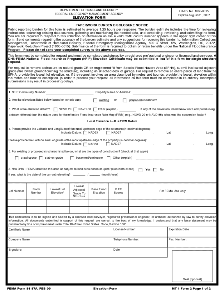
The Elevation Form, also known as the Flood Hazard Mapping Annex, is a critical document used in the United States to assess flood risk and determine elevation requirements for properties in flood-prone areas. This form is essential for homeowners and businesses seeking to comply with federal flood insurance regulations and to ensure accurate flood zone determinations. It provides necessary data regarding the elevation of structures relative to the base flood elevation, which is vital for flood insurance policies and community planning.
Steps to Complete the Elevation Form Flood Hazard Mapping Annex Federal
Completing the Elevation Form requires careful attention to detail. Here are the steps to ensure accurate completion:
- Gather necessary information about the property, including its location, current elevation, and flood zone designation.
- Obtain elevation data from reliable sources, such as surveys or local government records.
- Fill in the form accurately, ensuring all fields are completed as required.
- Review the form for any errors or omissions before submission.
- Submit the completed form to the appropriate local or federal agency as specified.
How to Obtain the Elevation Form Flood Hazard Mapping Annex Federal
The Elevation Form can be obtained through various channels. Individuals can access it via the official FEMA website or local government offices that handle floodplain management. It is often available in both digital and paper formats, making it accessible for users who prefer electronic submission or traditional mail. Ensure you have the most current version of the form to avoid any compliance issues.
Key Elements of the Elevation Form Flood Hazard Mapping Annex Federal
The Elevation Form includes several key elements that are crucial for its effectiveness:
- Property Information: This section requires details about the property, including address and flood zone classification.
- Elevation Data: Accurate elevation measurements must be provided, often requiring professional surveying.
- Certification: A certified professional must verify the elevation data, ensuring its accuracy for regulatory purposes.
- Submission Instructions: Clear guidelines on how to submit the form, including deadlines and acceptable formats.
Legal Use of the Elevation Form Flood Hazard Mapping Annex Federal
The Elevation Form serves a legal purpose in the context of flood insurance and compliance with federal regulations. Proper use of this form can help homeowners and businesses qualify for lower insurance premiums and avoid penalties associated with non-compliance. It is essential for users to understand the legal implications of the information provided, as inaccuracies may lead to significant financial consequences or legal disputes.
Examples of Using the Elevation Form Flood Hazard Mapping Annex Federal
There are various scenarios in which the Elevation Form is utilized:
- A homeowner seeking to rebuild after a flood may need to submit the form to ensure compliance with updated elevation requirements.
- A business in a flood-prone area may use the form to assess its risk and adjust its insurance coverage accordingly.
- Local governments may require the form for new construction projects in designated flood zones to ensure safety and compliance with federal guidelines.
Quick guide on how to complete elevation form flood hazard mapping annex federal
Easily Prepare Elevation Form Flood Hazard Mapping Annex Federal on Any Device
Managing documents online has become increasingly popular among businesses and individuals. It serves as an excellent environmentally friendly alternative to traditional printed and signed documents, allowing you to locate the right form and store it securely online. airSlate SignNow provides you with all the necessary tools to create, edit, and electronically sign your documents quickly and without delays. Handle Elevation Form Flood Hazard Mapping Annex Federal on any device using airSlate SignNow's Android or iOS applications and enhance any document-based process today.
The Easiest Way to Edit and eSign Elevation Form Flood Hazard Mapping Annex Federal Effortlessly
- Obtain Elevation Form Flood Hazard Mapping Annex Federal and select Get Form to begin.
- Utilize the tools available to complete your document.
- Emphasize relevant parts of the documents or obscure sensitive information with tools specifically designed for that purpose by airSlate SignNow.
- Generate your signature with the Sign feature, which takes mere seconds and holds the same legal validity as a conventional wet ink signature.
- Review the details and click the Done button to save your modifications.
- Select your preferred method of delivering your form, whether by email, SMS, or invitation link, or download it to your computer.
No more worrying about lost or misplaced documents, tedious form searches, or errors that require printing new document copies. airSlate SignNow addresses your document management needs in just a few clicks from any device you choose. Edit and eSign Elevation Form Flood Hazard Mapping Annex Federal while ensuring excellent communication at every stage of your form preparation process with airSlate SignNow.
Create this form in 5 minutes or less
Create this form in 5 minutes!
How to create an eSignature for the elevation form flood hazard mapping annex federal
How to create an electronic signature for a PDF online
How to create an electronic signature for a PDF in Google Chrome
How to create an e-signature for signing PDFs in Gmail
How to create an e-signature right from your smartphone
How to create an e-signature for a PDF on iOS
How to create an e-signature for a PDF on Android
People also ask
-
What are FEMA forms and how can airSlate SignNow help with them?
FEMA forms are official documents used for disaster assistance and recovery. airSlate SignNow simplifies the process of filling out and submitting these forms by providing an easy-to-use platform for eSigning and document management, ensuring that your submissions are timely and accurate.
-
Are there any costs associated with using airSlate SignNow for FEMA forms?
Yes, airSlate SignNow offers various pricing plans to accommodate different business needs. Each plan provides access to features that streamline the completion and signing of FEMA forms, making it a cost-effective solution for organizations of all sizes.
-
What features does airSlate SignNow offer for managing FEMA forms?
airSlate SignNow includes features such as customizable templates, secure eSigning, and document tracking, all of which enhance the management of FEMA forms. These tools help ensure that your forms are completed accurately and submitted without delays.
-
Can I integrate airSlate SignNow with other applications for FEMA forms?
Absolutely! airSlate SignNow offers integrations with popular applications like Google Drive, Dropbox, and CRM systems. This allows you to seamlessly manage your FEMA forms alongside other essential business documents and workflows.
-
How does airSlate SignNow ensure the security of my FEMA forms?
Security is a top priority for airSlate SignNow. The platform employs advanced encryption and compliance measures to protect your FEMA forms and sensitive information, ensuring that your documents are safe during the signing and submission process.
-
Is it easy to use airSlate SignNow for someone unfamiliar with digital forms?
Yes, airSlate SignNow is designed with user-friendliness in mind. Even if you're unfamiliar with digital forms, the intuitive interface makes it easy to navigate and complete FEMA forms without any technical expertise.
-
What benefits can I expect from using airSlate SignNow for FEMA forms?
Using airSlate SignNow for FEMA forms can signNowly reduce the time and effort required to complete and submit documents. The platform enhances efficiency, minimizes errors, and ensures that your forms are processed quickly, which is crucial during disaster recovery.
Get more for Elevation Form Flood Hazard Mapping Annex Federal
- Bus pass application form
- Slpcf report and rating form
- Contractor cash payment receipt form
- Fakturaunderlag form
- Ptax 342 r form
- 1445 request permission to work with an employer beyond 6 months on a working holiday or work and holiday visa form
- Community project evaluation template form
- Saam europe pilot protect association membership form
Find out other Elevation Form Flood Hazard Mapping Annex Federal
- Sign California Real Estate IOU Safe
- Sign Connecticut Real Estate Business Plan Template Simple
- How To Sign Wisconsin Plumbing Cease And Desist Letter
- Sign Colorado Real Estate LLC Operating Agreement Simple
- How Do I Sign Connecticut Real Estate Operating Agreement
- Sign Delaware Real Estate Quitclaim Deed Secure
- Sign Georgia Real Estate Business Plan Template Computer
- Sign Georgia Real Estate Last Will And Testament Computer
- How To Sign Georgia Real Estate LLC Operating Agreement
- Sign Georgia Real Estate Residential Lease Agreement Simple
- Sign Colorado Sports Lease Agreement Form Simple
- How To Sign Iowa Real Estate LLC Operating Agreement
- Sign Iowa Real Estate Quitclaim Deed Free
- How To Sign Iowa Real Estate Quitclaim Deed
- Sign Mississippi Orthodontists LLC Operating Agreement Safe
- Sign Delaware Sports Letter Of Intent Online
- How Can I Sign Kansas Real Estate Job Offer
- Sign Florida Sports Arbitration Agreement Secure
- How Can I Sign Kansas Real Estate Residential Lease Agreement
- Sign Hawaii Sports LLC Operating Agreement Free