Vegetation Survey Data Sheet Form


What is the Vegetation Survey Data Sheet
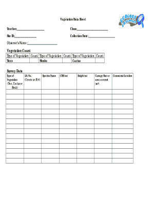
The vegetation survey data sheet is a structured document used by environmental professionals to collect and record data regarding plant species and their distribution in a specific area. This form is essential for ecological assessments, land management, and conservation efforts. It typically includes sections for identifying species, noting their abundance, and documenting environmental conditions. By standardizing data collection, the vegetation survey data sheet helps ensure consistency and accuracy in environmental studies.
How to use the Vegetation Survey Data Sheet
Using the vegetation survey data sheet involves several key steps. First, familiarize yourself with the specific sections of the form, which may include plant identification, site conditions, and geographic coordinates. Next, conduct a field survey, observing and recording the relevant data directly onto the sheet. It is important to follow any guidelines provided for species identification and data entry. Once completed, the data sheet can be analyzed or submitted to relevant authorities for further processing.
Key elements of the Vegetation Survey Data Sheet
The vegetation survey data sheet contains several critical components that facilitate effective data collection. Key elements typically include:
- Site Information: Location, date, and time of the survey.
- Species Identification: Common and scientific names of observed plants.
- Abundance Estimates: Quantitative measures of species presence.
- Environmental Conditions: Notes on soil type, moisture levels, and other ecological factors.
These elements work together to provide a comprehensive overview of the vegetation in the surveyed area.
Steps to complete the Vegetation Survey Data Sheet
Completing the vegetation survey data sheet involves a systematic approach to ensure accuracy and thoroughness. Follow these steps:
- Prepare for the survey by gathering necessary tools, such as identification guides and GPS devices.
- Visit the designated survey site and record the date and time.
- Identify plant species present and fill in the corresponding sections of the data sheet.
- Estimate the abundance of each species and document any notable environmental conditions.
- Review the completed data sheet for completeness and accuracy before submission.
Legal use of the Vegetation Survey Data Sheet
The legal use of the vegetation survey data sheet is governed by various environmental regulations and standards. When filled out correctly, this form can serve as a legally binding document in environmental assessments and permitting processes. It is crucial to ensure that the data collected adheres to relevant local, state, and federal guidelines. Proper documentation can support compliance with environmental laws and facilitate the approval of conservation projects.
Examples of using the Vegetation Survey Data Sheet
There are numerous practical applications for the vegetation survey data sheet. Examples include:
- Conducting baseline ecological assessments for land development projects.
- Monitoring changes in plant communities over time in response to environmental management strategies.
- Supporting research studies focused on biodiversity and ecosystem health.
These examples illustrate the versatility and importance of the vegetation survey data sheet in various ecological contexts.
Quick guide on how to complete vegetation survey data sheet
Effortlessly Complete vegetation survey data sheet on Any Device
Digital document management has become increasingly favored by companies and individuals alike. It serves as an ideal environmentally friendly alternative to conventional printed and signed documents, allowing you to obtain the necessary forms and securely store them online. airSlate SignNow equips you with all the tools necessary to create, edit, and electronically sign your documents swiftly and without hold-ups. Manage vegetation survey data sheet on any device using airSlate SignNow's Android or iOS applications and enhance any document-driven process today.
How to Edit and Electronically Sign vegetation survey data sheet with Ease
- Find vegetation survey data sheet and click Get Form to begin.
- Utilize the tools we provide to finalize your document.
- Emphasize pertinent sections of the documents or redact sensitive information using the tools specifically designed by airSlate SignNow for such tasks.
- Generate your signature with the Sign tool, which takes mere seconds and holds the same legal validity as a traditional ink signature.
- Review the information and click on the Done button to save your modifications.
- Select your preferred method for sending your form, whether by email, SMS, or invitation link, or download it to your computer.
Eliminate the hassle of lost or misplaced documents, tedious form searching, or mistakes that necessitate printing new document copies. airSlate SignNow meets your document management needs in just a few clicks from any device of your choice. Edit and electronically sign vegetation survey data sheet to ensure excellent communication at every step of your form preparation process with airSlate SignNow.
Create this form in 5 minutes or less
Related searches to vegetation survey data sheet
Create this form in 5 minutes!
How to create an eSignature for the vegetation survey data sheet
How to create an electronic signature for a PDF online
How to create an electronic signature for a PDF in Google Chrome
How to create an e-signature for signing PDFs in Gmail
How to create an e-signature right from your smartphone
How to create an e-signature for a PDF on iOS
How to create an e-signature for a PDF on Android
People also ask vegetation survey data sheet
-
What is a vegetation survey data sheet?
A vegetation survey data sheet is a structured form used to collect and record data about plant species in a specific area. This sheet helps in documenting biodiversity, monitoring ecosystem health, and guiding conservation efforts. With airSlate SignNow, users can easily create, share, and sign these sheets electronically.
-
How does airSlate SignNow enhance the vegetation survey data sheet process?
airSlate SignNow streamlines the process of handling vegetation survey data sheets by allowing for quick electronic signatures and efficient document management. Users can send, sign, and track these sheets in real-time, ensuring that critical data is captured accurately and promptly. This signNowly reduces paperwork and increases operational efficiency.
-
Is there a cost associated with using airSlate SignNow for vegetation survey data sheets?
Yes, while airSlate SignNow offers various pricing plans, the cost can be tailored to your specific needs for managing vegetation survey data sheets. It is designed to be cost-effective and can provide businesses with signNow savings in time and resources. A free trial is also available to explore its features before committing.
-
Can I customize my vegetation survey data sheet with airSlate SignNow?
Absolutely! airSlate SignNow allows you to customize your vegetation survey data sheet to fit your unique requirements. You can add fields, adjust formatting, and incorporate branding, ensuring that the sheet aligns with your organization’s standards and goals.
-
What integrations does airSlate SignNow offer for managing vegetation survey data sheets?
airSlate SignNow seamlessly integrates with several popular tools and applications, enhancing how you manage vegetation survey data sheets. This includes integrations with cloud storage services and project management tools, facilitating better data organization and collaboration among teams.
-
How do I ensure the security of my vegetation survey data sheets with airSlate SignNow?
airSlate SignNow prioritizes security for your vegetation survey data sheets by employing advanced encryption methods and secure storage solutions. This ensures that your sensitive data remains protected during transmission and while stored in the cloud. Compliance with industry standards also guarantees data privacy and security.
-
Can I track the completion of my vegetation survey data sheets with airSlate SignNow?
Yes, airSlate SignNow provides tracking features that allow you to monitor the status of your vegetation survey data sheets. You will receive notifications regarding when documents are viewed, signed, and completed, giving you complete control over the document's lifecycle and ensuring timely data collection.
Get more for vegetation survey data sheet
- F84 final layout color blm form
- For renaissance umiat llc blm form
- Mi 2210 michigan underpayment of estimated income tax form
- Michigan adjustments of capital gains and losses mi 1040d 771784754 form
- Handyman agreement template form
- Hard money loan agreement template form
- Hardware agreement template form
- Hardware as a service agreement template form
Find out other vegetation survey data sheet
- Can I eSign Virginia Life Sciences Job Description Template
- eSign Massachusetts Legal Promissory Note Template Safe
- eSign West Virginia Life Sciences Agreement Later
- How To eSign Michigan Legal Living Will
- eSign Alabama Non-Profit Business Plan Template Easy
- eSign Mississippi Legal Last Will And Testament Secure
- eSign California Non-Profit Month To Month Lease Myself
- eSign Colorado Non-Profit POA Mobile
- How Can I eSign Missouri Legal RFP
- eSign Missouri Legal Living Will Computer
- eSign Connecticut Non-Profit Job Description Template Now
- eSign Montana Legal Bill Of Lading Free
- How Can I eSign Hawaii Non-Profit Cease And Desist Letter
- Can I eSign Florida Non-Profit Residential Lease Agreement
- eSign Idaho Non-Profit Business Plan Template Free
- eSign Indiana Non-Profit Business Plan Template Fast
- How To eSign Kansas Non-Profit Business Plan Template
- eSign Indiana Non-Profit Cease And Desist Letter Free
- eSign Louisiana Non-Profit Quitclaim Deed Safe
- How Can I eSign Maryland Non-Profit Credit Memo