Wetland Determination Form


What is the Wetland Determination
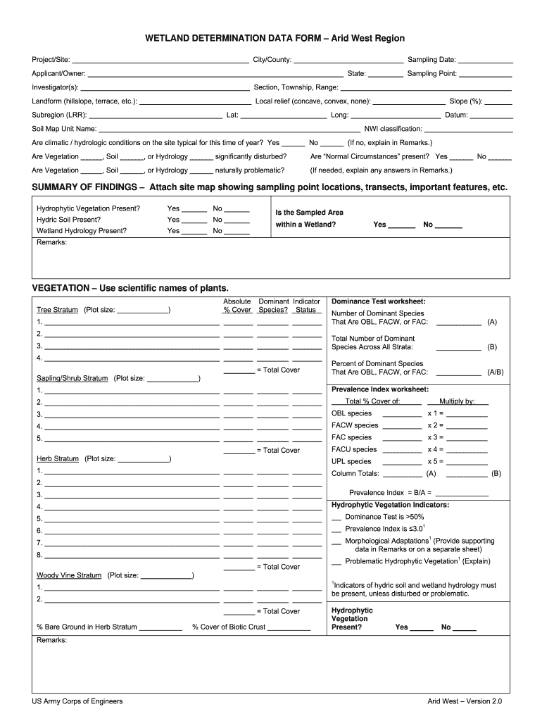
The Wetland Determination is a formal process used to identify and delineate wetland areas in the United States. This determination is essential for regulatory compliance, particularly under the Clean Water Act. It helps landowners and developers understand the presence of wetlands on their property, which can significantly impact land use and development plans. The determination typically involves field assessments by qualified professionals, who evaluate soil, vegetation, and hydrology to confirm wetland characteristics.
How to use the Wetland Determination
Using the Wetland Determination involves several steps that ensure compliance with federal and state regulations. First, landowners should obtain the determination from the appropriate regulatory agency, usually the U.S. Army Corps of Engineers (USACE). Once received, this document can guide decisions regarding land development, agricultural practices, and environmental protection measures. It is crucial to refer to the determination when planning any activities that may affect wetland areas, as it outlines specific regulations and restrictions applicable to those zones.
Steps to complete the Wetland Determination
Completing the Wetland Determination involves a systematic approach:
- Initial Assessment: Conduct a preliminary review of the property to identify potential wetland areas based on existing maps and local knowledge.
- Field Investigation: Engage a qualified professional to perform a field assessment, examining soil types, vegetation, and hydrological conditions.
- Documentation: Compile findings into a formal report that includes maps, photographs, and data supporting the wetland classification.
- Submission: Submit the report to the appropriate agency for review and approval. This may include the USACE and state environmental agencies.
- Follow-Up: Address any feedback or requests for additional information from regulatory agencies to finalize the determination.
Legal use of the Wetland Determination
The legal use of the Wetland Determination is crucial for ensuring compliance with environmental regulations. It serves as a binding document that outlines the status of wetland areas and the associated legal protections. Landowners must adhere to the guidelines set forth in the determination, as failure to do so can result in penalties, including fines and restrictions on land use. It is advisable to consult legal experts when interpreting the implications of the determination on property rights and development plans.
Who Issues the Form
The Wetland Determination form is typically issued by the U.S. Army Corps of Engineers (USACE) or state environmental agencies. These authorities are responsible for regulating wetlands under federal and state laws. The issuance process often involves a thorough review of submitted documentation and field assessments conducted by qualified professionals. Understanding which agency to approach for the determination is essential for compliance and proper land management.
Required Documents
To obtain a Wetland Determination, several documents are generally required:
- Property Deeds: Proof of ownership or interest in the property.
- Previous Assessments: Any prior wetland assessments or determinations related to the property.
- Maps: Topographic and soil maps that illustrate the property boundaries and existing conditions.
- Field Data: Results from field investigations, including soil samples and vegetation surveys.
Quick guide on how to complete arid west wetland determination form
Discover the simplest method to complete and sign your Wetland Determination
Are you still spending time preparing your official documents on paper instead of doing it digitally? airSlate SignNow offers a more efficient way to complete and sign your Wetland Determination and similar forms for public services. Our advanced eSignature solution equips you with everything necessary to handle paperwork promptly and in line with official standards - robust PDF editing, managing, securing, signing, and sharing options all available through an intuitive interface.
Only a few steps are needed to finish filling out and signing your Wetland Determination:
- Upload the editable template to the editor using the Get Form button.
- Review the information required in your Wetland Determination.
- Navigate between the fields with the Next button to ensure nothing is overlooked.
- Utilize Text, Check, and Cross tools to populate the fields with your details.
- Update the content with Text boxes or Images from the upper toolbar.
- Emphasize what is signNow or Blackout sections that are no longer relevant.
- Click on Sign to generate a legally valid eSignature using any preferred option.
- Insert the Date beside your signature and conclude your task using the Done button.
Store your completed Wetland Determination in the Documents folder within your account, download it, or upload it to your chosen cloud storage. Our service also offers versatile file sharing. There's no need to print your forms when filing them at the appropriate public office - do so via email, fax, or by requesting USPS “snail mail” delivery from your account. Give it a try today!
Create this form in 5 minutes or less
FAQs
-
Do military members have to pay any fee for leave or fiancee forms?
NOOOOOOO. You are talking to a military romance scammer. I received an email from the US Army that directly answers your question that is pasted below please keep reading.I believe you are the victim of a military Romance Scam whereas the person you are talking to is a foreign national posing as an American Soldier claiming to be stationed overseas on a peacekeeping mission. That's the key to the scam they always claim to be on a peacekeeping mission.Part of their scam is saying that they have no access to their money that their mission is highly dangerous.If your boyfriend girlfriend/future husband/wife is asking you to do the following or has exhibited this behavior, it is a most likely a scam:Moves to private messaging site immediately after meeting you on Facebook or SnapChat or Instagram or some dating or social media site. Often times they delete the site you met them on right after they asked you to move to a more private messaging siteProfesses love to you very quickly & seems to quote poems and song lyrics along with using their own sort of broken language, as they profess their love and devotion quickly. They also showed concern for your health and love for your family.Promises marriage as soon as he/she gets to state for leave that they asked you to pay for.They Requests money (wire transfers) and Amazon, iTune ,Verizon, etc gift cards, for medicine, religious practices, and leaves to come home, internet access, complete job assignments, help sick friend, get him out of trouble, or anything that sounds fishy.The military does provide all the soldier needs including food medical Care and transportation for leave. Trust me, I lived it, you are probably being scammed. I am just trying to show you examples that you are most likely being connned.Below is an email response I received after I sent an inquiry to the US government when I discovered I was scammed. I received this wonderful response back with lots of useful links on how to find and report your scammer. And how to learn more about Romance Scams.Right now you can also copy the picture he gave you and do a google image search and you will hopefully see the pictures of the real person he is impersonating. this doesn't always work and take some digging. if you find the real person you can direct message them and alert them that their image is being used for scamming.Good Luck to you and I'm sorry this may be happening to you. please continue reading the government response I received below it's very informative. You have contacted an email that is monitored by the U.S. Army Criminal Investigation Command. Unfortunately, this is a common concern. We assure you there is never any reason to send money to anyone claiming to be a Soldier online. If you have only spoken with this person online, it is likely they are not a U.S. Soldier at all. If this is a suspected imposter social media profile, we urge you to report it to that platform as soon as possible. Please continue reading for more resources and answers to other frequently asked questions: How to report an imposter Facebook profile: Caution-https://www.facebook.com/help/16... < Caution-https://www.facebook.com/help/16... > Answers to frequently asked questions: - Soldiers and their loved ones are not charged money so that the Soldier can go on leave. - Soldiers are not charged money for secure communications or leave. - Soldiers do not need permission to get married. - Soldiers emails are in this format: john.doe.mil@mail.mil < Caution-mailto: john.doe.mil@mail.mil > anything ending in .us or .com is not an official email account. - Soldiers have medical insurance, which pays for their medical costs when treated at civilian health care facilities worldwide – family and friends do not need to pay their medical expenses. - Military aircraft are not used to transport Privately Owned Vehicles. - Army financial offices are not used to help Soldiers buy or sell items of any kind. - Soldiers deployed to Combat Zones do not need to solicit money from the public to feed or house themselves or their troops. - Deployed Soldiers do not find large unclaimed sums of money and need your help to get that money out of the country. Anyone who tells you one of the above-listed conditions/circumstances is true is likely posing as a Soldier and trying to steal money from you. We would urge you to immediately cease all contact with this individual. For more information on avoiding online scams and to report this crime, please see the following sites and articles: This article may help clarify some of the tricks social media scammers try to use to take advantage of people: Caution-https://www.army.mil/article/61432/< Caution-https://www.army.mil/article/61432/> CID advises vigilance against 'romance scams,' scammers impersonating Soldiers Caution-https://www.army.mil/article/180749 < Caution-https://www.army.mil/article/180749 > FBI Internet Crime Complaint Center: Caution-http://www.ic3.gov/default.aspx< Caution-http://www.ic3.gov/default.aspx> U.S. Army investigators warn public against romance scams: Caution-https://www.army.mil/article/130...< Caution-https://www.army.mil/article/130...> DOD warns troops, families to be cybercrime smart -Caution-http://www.army.mil/article/1450...< Caution-http://www.army.mil/article/1450...> Use caution with social networking Caution-https://www.army.mil/article/146...< Caution-https://www.army.mil/article/146...> Please see our frequently asked questions section under scams and legal issues. Caution-http://www.army.mil/faq/ < Caution-http://www.army.mil/faq/ > or visit Caution-http://www.cid.army.mil/ < Caution-http://www.cid.army.mil/ >. The challenge with most scams is determining if an individual is a legitimate member of the US Army. Based on the Privacy Act of 1974, we cannot provide this information. If concerned about a scam you may contact the Better Business Bureau (if it involves a solicitation for money), or local law enforcement. If you're involved in a Facebook or dating site scam, you are free to contact us direct; (571) 305-4056. If you have a social security number, you can find information about Soldiers online at Caution-https://www.dmdc.osd.mil/appj/sc... < Caution-https://www.dmdc.osd.mil/appj/sc... > . While this is a free search, it does not help you locate a retiree, but it can tell you if the Soldier is active duty or not. If more information is needed such as current duty station or location, you can contact the Commander Soldier's Records Data Center (SRDC) by phone or mail and they will help you locate individuals on active duty only, not retirees. There is a fee of $3.50 for businesses to use this service. The check or money order must be made out to the U.S. Treasury. It is not refundable. The address is: Commander Soldier's Records Data Center (SRDC) 8899 East 56th Street Indianapolis, IN 46249-5301 Phone: 1-866-771-6357 In addition, it is not possible to remove social networking site profiles without legitimate proof of identity theft or a scam. If you suspect fraud on this site, take a screenshot of any advances for money or impersonations and report the account on the social networking platform immediately. Please submit all information you have on this incident to Caution-www.ic3.gov < Caution-http://www.ic3.gov > (FBI website, Internet Criminal Complaint Center), immediately stop contact with the scammer (you are potentially providing them more information which can be used to scam you), and learn how to protect yourself against these scams at Caution-http://www.ftc.gov < Caution-http://www.ftc.gov > (Federal Trade Commission's website)
-
How can I fill out Google's intern host matching form to optimize my chances of receiving a match?
I was selected for a summer internship 2016.I tried to be very open while filling the preference form: I choose many products as my favorite products and I said I'm open about the team I want to join.I even was very open in the location and start date to get host matching interviews (I negotiated the start date in the interview until both me and my host were happy.) You could ask your recruiter to review your form (there are very cool and could help you a lot since they have a bigger experience).Do a search on the potential team.Before the interviews, try to find smart question that you are going to ask for the potential host (do a search on the team to find nice and deep questions to impress your host). Prepare well your resume.You are very likely not going to get algorithm/data structure questions like in the first round. It's going to be just some friendly chat if you are lucky. If your potential team is working on something like machine learning, expect that they are going to ask you questions about machine learning, courses related to machine learning you have and relevant experience (projects, internship). Of course you have to study that before the interview. Take as long time as you need if you feel rusty. It takes some time to get ready for the host matching (it's less than the technical interview) but it's worth it of course.
-
How do I fill out the form of DU CIC? I couldn't find the link to fill out the form.
Just register on the admission portal and during registration you will get an option for the entrance based course. Just register there. There is no separate form for DU CIC.
-
How do you know if you need to fill out a 1099 form?
Assuming that you are talking about 1099-MISC. Note that there are other 1099s.check this post - Form 1099 MISC Rules & RegulationsQuick answer - A Form 1099 MISC must be filed for each person to whom payment is made of:$600 or more for services performed for a trade or business by people not treated as employees;Rent or prizes and awards that are not for service ($600 or more) and royalties ($10 or more);any fishing boat proceeds,gross proceeds of $600, or more paid to an attorney during the year, orWithheld any federal income tax under the backup withholding rules regardless of the amount of the payment, etc.
Create this form in 5 minutes!
How to create an eSignature for the arid west wetland determination form
How to make an electronic signature for your Arid West Wetland Determination Form in the online mode
How to generate an eSignature for your Arid West Wetland Determination Form in Google Chrome
How to create an electronic signature for signing the Arid West Wetland Determination Form in Gmail
How to create an electronic signature for the Arid West Wetland Determination Form right from your smart phone
How to create an eSignature for the Arid West Wetland Determination Form on iOS
How to make an eSignature for the Arid West Wetland Determination Form on Android OS
People also ask
-
What is Wetland Determination?
Wetland Determination is a process used to identify and delineate wetlands based on specific criteria set by regulatory agencies. This determination is crucial for compliance with environmental regulations when planning land use or development projects. Understanding Wetland Determination helps businesses avoid potential legal issues and ensures protection of valuable ecosystems.
-
How can airSlate SignNow assist with Wetland Determination documentation?
airSlate SignNow provides an easy-to-use platform to streamline the documentation needed for Wetland Determination. With features like eSigning and document templates, users can efficiently manage their paperwork, ensuring timely submissions and compliance with local regulations. This efficiency can signNowly reduce the time spent on administrative tasks related to Wetland Determination.
-
What are the benefits of using airSlate SignNow for Wetland Determination processes?
Using airSlate SignNow for Wetland Determination processes offers several benefits, including increased efficiency and reduced paperwork hassles. The platform allows for quick eSigning and document sharing, which accelerates project timelines. Additionally, it enhances collaboration among team members and stakeholders involved in the Wetland Determination process.
-
Is airSlate SignNow cost-effective for Wetland Determination projects?
Yes, airSlate SignNow is known for being a cost-effective solution for Wetland Determination projects. With competitive pricing plans, businesses can choose a package that meets their needs without overspending. This affordability, combined with robust features, makes airSlate SignNow an attractive option for managing Wetland Determination documentation.
-
Can I integrate airSlate SignNow with other tools for Wetland Determination?
Absolutely! airSlate SignNow offers seamless integrations with various tools that can enhance your Wetland Determination processes. Whether you're using project management software or CRM systems, you can easily connect and streamline your workflows. This integration capability allows for a more efficient handling of Wetland Determination tasks.
-
What features does airSlate SignNow offer that are beneficial for Wetland Determination?
airSlate SignNow includes features such as customizable templates, bulk sending, and an intuitive eSignature process that are particularly beneficial for Wetland Determination. These features help ensure that all necessary documents are properly formatted and signed, which is essential for compliance. Additionally, the platform’s user-friendly interface makes it accessible for teams at all levels.
-
How does airSlate SignNow ensure the security of Wetland Determination documents?
airSlate SignNow prioritizes the security of your Wetland Determination documents through advanced encryption and compliance with industry standards. This ensures that sensitive information is protected during transmission and storage. Users can trust that their data related to Wetland Determination is safe and secure on our platform.
Get more for Wetland Determination
- Fillable online form it 203 att2019other tax credits and
- Wwwtaxformfinderorgindexnewyorknew york form ct 261 claim for empire state film post
- Fillable online dx1slceezt1vd cloudfront state of form
- Wwwstategovincome taxincome tax united states department of state form
- Form it 203 gr att b schedule b yonkers group return for nonresident partners tax year 2021
- Printable 2020 south carolina form sch nr schedule nr nonresident schedule
- Printable new york form it 638 start up ny tax elimination
- Sc 1065 form
Find out other Wetland Determination
- Electronic signature Oklahoma Real estate document Mobile
- Electronic signature Louisiana Real estate forms Secure
- Electronic signature Louisiana Real estate investment proposal template Fast
- Electronic signature Maine Real estate investment proposal template Myself
- eSignature Alabama Pet Addendum to Lease Agreement Simple
- eSignature Louisiana Pet Addendum to Lease Agreement Safe
- eSignature Minnesota Pet Addendum to Lease Agreement Fast
- Electronic signature South Carolina Real estate proposal template Fast
- Electronic signature Rhode Island Real estate investment proposal template Computer
- How To Electronic signature Virginia Real estate investment proposal template
- How To Electronic signature Tennessee Franchise Contract
- Help Me With Electronic signature California Consulting Agreement Template
- How To Electronic signature Kentucky Investment Contract
- Electronic signature Tennessee Consulting Agreement Template Fast
- How To Electronic signature California General Power of Attorney Template
- eSignature Alaska Bill of Sale Immovable Property Online
- Can I Electronic signature Delaware General Power of Attorney Template
- Can I Electronic signature Michigan General Power of Attorney Template
- Can I Electronic signature Minnesota General Power of Attorney Template
- How Do I Electronic signature California Distributor Agreement Template