Wetland Determination Form Great Plains Region Fillable


What is the Wetland Determination Form Great Plains Region Fillable
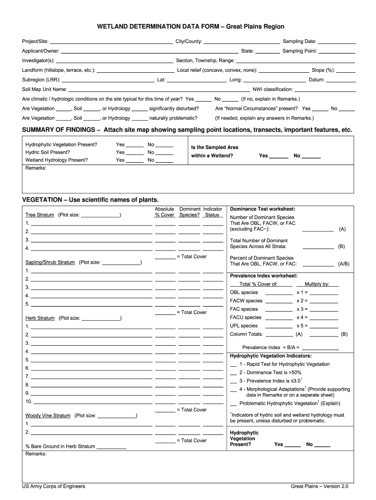
The Wetland Determination Form Great Plains Region is a crucial document used to assess and confirm the presence of wetlands in specific areas. This form is essential for landowners, developers, and environmental professionals who need to determine the wetland status of a property. It helps ensure compliance with federal regulations and local laws regarding wetland management and protection. The fillable version allows users to complete the form digitally, streamlining the submission process and reducing the likelihood of errors.
Steps to complete the Wetland Determination Form Great Plains Region Fillable
Completing the Wetland Determination Form involves several key steps to ensure accuracy and compliance:
- Gather necessary information about the property, including location, size, and existing environmental conditions.
- Fill out all required fields on the form, paying close attention to specific questions regarding wetland characteristics.
- Attach any supplemental documents that may support your determination, such as maps or photographs of the site.
- Review the completed form for accuracy and completeness before submission.
- Submit the form through the appropriate channels, whether online, by mail, or in person, as specified by local regulations.
Legal use of the Wetland Determination Form Great Plains Region Fillable
The legal use of the Wetland Determination Form is governed by federal and state regulations that protect wetland areas. Proper completion and submission of this form are necessary to avoid penalties and ensure that development activities comply with the Clean Water Act and other environmental laws. The form serves as an official record of the wetland status of a property, which can be critical during land use planning and environmental assessments.
Key elements of the Wetland Determination Form Great Plains Region Fillable
Understanding the key elements of the Wetland Determination Form is essential for effective completion:
- Property Information: This section requires details about the location and ownership of the property.
- Wetland Indicators: Users must identify specific indicators that suggest the presence of wetlands, such as soil types and vegetation.
- Attachments: Any supporting documents, such as maps or photographs, should be included to provide additional context.
- Signature: The form must be signed by the individual responsible for the information provided, affirming its accuracy.
How to obtain the Wetland Determination Form Great Plains Region Fillable
The Wetland Determination Form can typically be obtained through local environmental agencies or the U.S. Army Corps of Engineers. Many agencies provide downloadable versions of the form on their websites, allowing users to access the fillable format easily. Additionally, some offices may offer printed copies upon request. It is important to ensure that you are using the most current version of the form to comply with regulations.
Form Submission Methods (Online / Mail / In-Person)
Submitting the Wetland Determination Form can be done through various methods, depending on local regulations and preferences:
- Online Submission: If permitted, users can submit the completed form electronically through designated online platforms.
- Mail: The form can be printed and mailed to the appropriate agency address, ensuring that it is sent with sufficient postage and tracking.
- In-Person: Some individuals may choose to deliver the form in person to expedite processing or to clarify any questions directly with agency staff.
Quick guide on how to complete wetland plains form
Discover the easiest method to complete and sign your Wetland Determination Form Great Plains Region Fillable
Are you still spending time on paper documentation instead of handling it online? airSlate SignNow provides a superior method to complete and sign your Wetland Determination Form Great Plains Region Fillable and similar forms for public services. Our innovative electronic signature solution equips you with all the tools necessary to manage documents swiftly and in line with official standards - advanced PDF editing, managing, securing, signing, and sharing features all available in a user-friendly interface.
Only a few steps are needed to complete and sign your Wetland Determination Form Great Plains Region Fillable:
- Upload the editable template to the editor using the Get Form button.
- Review what information you need to enter in your Wetland Determination Form Great Plains Region Fillable.
- Move between the fields using the Next button to ensure nothing is overlooked.
- Utilize Text, Check, and Cross tools to fill in the gaps with your information.
- Update the content with Text boxes or Images from the top menu.
- Emphasize what is important or Obscure sections that are no longer relevant.
- Select Sign to create a legally binding electronic signature using any method you prefer.
- Add the Date next to your signature and conclude your work with the Done button.
Store your finalized Wetland Determination Form Great Plains Region Fillable in the Documents folder within your account, download it, or transfer it to your preferred cloud storage. Our solution also offers versatile file sharing options. There's no need to print your forms when you need to submit them to the appropriate public office - do it via email, fax, or by requesting a USPS “snail mail” dispatch from your account. Try it out today!
Create this form in 5 minutes or less
FAQs
-
Do military members have to pay any fee for leave or fiancee forms?
NOOOOOOO. You are talking to a military romance scammer. I received an email from the US Army that directly answers your question that is pasted below please keep reading.I believe you are the victim of a military Romance Scam whereas the person you are talking to is a foreign national posing as an American Soldier claiming to be stationed overseas on a peacekeeping mission. That's the key to the scam they always claim to be on a peacekeeping mission.Part of their scam is saying that they have no access to their money that their mission is highly dangerous.If your boyfriend girlfriend/future husband/wife is asking you to do the following or has exhibited this behavior, it is a most likely a scam:Moves to private messaging site immediately after meeting you on Facebook or SnapChat or Instagram or some dating or social media site. Often times they delete the site you met them on right after they asked you to move to a more private messaging siteProfesses love to you very quickly & seems to quote poems and song lyrics along with using their own sort of broken language, as they profess their love and devotion quickly. They also showed concern for your health and love for your family.Promises marriage as soon as he/she gets to state for leave that they asked you to pay for.They Requests money (wire transfers) and Amazon, iTune ,Verizon, etc gift cards, for medicine, religious practices, and leaves to come home, internet access, complete job assignments, help sick friend, get him out of trouble, or anything that sounds fishy.The military does provide all the soldier needs including food medical Care and transportation for leave. Trust me, I lived it, you are probably being scammed. I am just trying to show you examples that you are most likely being connned.Below is an email response I received after I sent an inquiry to the US government when I discovered I was scammed. I received this wonderful response back with lots of useful links on how to find and report your scammer. And how to learn more about Romance Scams.Right now you can also copy the picture he gave you and do a google image search and you will hopefully see the pictures of the real person he is impersonating. this doesn't always work and take some digging. if you find the real person you can direct message them and alert them that their image is being used for scamming.Good Luck to you and I'm sorry this may be happening to you. please continue reading the government response I received below it's very informative. You have contacted an email that is monitored by the U.S. Army Criminal Investigation Command. Unfortunately, this is a common concern. We assure you there is never any reason to send money to anyone claiming to be a Soldier online. If you have only spoken with this person online, it is likely they are not a U.S. Soldier at all. If this is a suspected imposter social media profile, we urge you to report it to that platform as soon as possible. Please continue reading for more resources and answers to other frequently asked questions: How to report an imposter Facebook profile: Caution-https://www.facebook.com/help/16... < Caution-https://www.facebook.com/help/16... > Answers to frequently asked questions: - Soldiers and their loved ones are not charged money so that the Soldier can go on leave. - Soldiers are not charged money for secure communications or leave. - Soldiers do not need permission to get married. - Soldiers emails are in this format: john.doe.mil@mail.mil < Caution-mailto: john.doe.mil@mail.mil > anything ending in .us or .com is not an official email account. - Soldiers have medical insurance, which pays for their medical costs when treated at civilian health care facilities worldwide – family and friends do not need to pay their medical expenses. - Military aircraft are not used to transport Privately Owned Vehicles. - Army financial offices are not used to help Soldiers buy or sell items of any kind. - Soldiers deployed to Combat Zones do not need to solicit money from the public to feed or house themselves or their troops. - Deployed Soldiers do not find large unclaimed sums of money and need your help to get that money out of the country. Anyone who tells you one of the above-listed conditions/circumstances is true is likely posing as a Soldier and trying to steal money from you. We would urge you to immediately cease all contact with this individual. For more information on avoiding online scams and to report this crime, please see the following sites and articles: This article may help clarify some of the tricks social media scammers try to use to take advantage of people: Caution-https://www.army.mil/article/61432/< Caution-https://www.army.mil/article/61432/> CID advises vigilance against 'romance scams,' scammers impersonating Soldiers Caution-https://www.army.mil/article/180749 < Caution-https://www.army.mil/article/180749 > FBI Internet Crime Complaint Center: Caution-http://www.ic3.gov/default.aspx< Caution-http://www.ic3.gov/default.aspx> U.S. Army investigators warn public against romance scams: Caution-https://www.army.mil/article/130...< Caution-https://www.army.mil/article/130...> DOD warns troops, families to be cybercrime smart -Caution-http://www.army.mil/article/1450...< Caution-http://www.army.mil/article/1450...> Use caution with social networking Caution-https://www.army.mil/article/146...< Caution-https://www.army.mil/article/146...> Please see our frequently asked questions section under scams and legal issues. Caution-http://www.army.mil/faq/ < Caution-http://www.army.mil/faq/ > or visit Caution-http://www.cid.army.mil/ < Caution-http://www.cid.army.mil/ >. The challenge with most scams is determining if an individual is a legitimate member of the US Army. Based on the Privacy Act of 1974, we cannot provide this information. If concerned about a scam you may contact the Better Business Bureau (if it involves a solicitation for money), or local law enforcement. If you're involved in a Facebook or dating site scam, you are free to contact us direct; (571) 305-4056. If you have a social security number, you can find information about Soldiers online at Caution-https://www.dmdc.osd.mil/appj/sc... < Caution-https://www.dmdc.osd.mil/appj/sc... > . While this is a free search, it does not help you locate a retiree, but it can tell you if the Soldier is active duty or not. If more information is needed such as current duty station or location, you can contact the Commander Soldier's Records Data Center (SRDC) by phone or mail and they will help you locate individuals on active duty only, not retirees. There is a fee of $3.50 for businesses to use this service. The check or money order must be made out to the U.S. Treasury. It is not refundable. The address is: Commander Soldier's Records Data Center (SRDC) 8899 East 56th Street Indianapolis, IN 46249-5301 Phone: 1-866-771-6357 In addition, it is not possible to remove social networking site profiles without legitimate proof of identity theft or a scam. If you suspect fraud on this site, take a screenshot of any advances for money or impersonations and report the account on the social networking platform immediately. Please submit all information you have on this incident to Caution-www.ic3.gov < Caution-http://www.ic3.gov > (FBI website, Internet Criminal Complaint Center), immediately stop contact with the scammer (you are potentially providing them more information which can be used to scam you), and learn how to protect yourself against these scams at Caution-http://www.ftc.gov < Caution-http://www.ftc.gov > (Federal Trade Commission's website)
-
How can I fill out Google's intern host matching form to optimize my chances of receiving a match?
I was selected for a summer internship 2016.I tried to be very open while filling the preference form: I choose many products as my favorite products and I said I'm open about the team I want to join.I even was very open in the location and start date to get host matching interviews (I negotiated the start date in the interview until both me and my host were happy.) You could ask your recruiter to review your form (there are very cool and could help you a lot since they have a bigger experience).Do a search on the potential team.Before the interviews, try to find smart question that you are going to ask for the potential host (do a search on the team to find nice and deep questions to impress your host). Prepare well your resume.You are very likely not going to get algorithm/data structure questions like in the first round. It's going to be just some friendly chat if you are lucky. If your potential team is working on something like machine learning, expect that they are going to ask you questions about machine learning, courses related to machine learning you have and relevant experience (projects, internship). Of course you have to study that before the interview. Take as long time as you need if you feel rusty. It takes some time to get ready for the host matching (it's less than the technical interview) but it's worth it of course.
-
How do I fill out the form of DU CIC? I couldn't find the link to fill out the form.
Just register on the admission portal and during registration you will get an option for the entrance based course. Just register there. There is no separate form for DU CIC.
-
How do you know if you need to fill out a 1099 form?
Assuming that you are talking about 1099-MISC. Note that there are other 1099s.check this post - Form 1099 MISC Rules & RegulationsQuick answer - A Form 1099 MISC must be filed for each person to whom payment is made of:$600 or more for services performed for a trade or business by people not treated as employees;Rent or prizes and awards that are not for service ($600 or more) and royalties ($10 or more);any fishing boat proceeds,gross proceeds of $600, or more paid to an attorney during the year, orWithheld any federal income tax under the backup withholding rules regardless of the amount of the payment, etc.
-
How can I make it easier for users to fill out a form on mobile apps?
I’ll tell you a secret - you can thank me later for this.If you want to make the form-filling experience easy for a user - make sure that you have a great UI to offer.Everything boils down to UI at the end.Axonator is one of the best mobile apps to collect data since it offers powerful features bundled with a simple UI.The problem with most of the mobile form apps is that they are overloaded with features that aren’t really necessary.The same doesn’t hold true for Axonator. It has useful features but it is very unlikely that the user will feel overwhelmed in using them.So, if you are inclined towards having greater form completion rates for your survey or any data collection projects, then Axonator is the way to go.Apart from that, there are other features that make the data collection process faster like offline data collection, rich data capture - audio, video, images, QR code & barcode data capture, live location & time capture, and more!Check all the features here!You will be able to complete more surveys - because productivity will certainly shoot up.Since you aren’t using paper forms, errors will drop signNowly.The cost of the paper & print will be saved - your office expenses will drop dramatically.No repeat work. No data entry. Time & money saved yet again.Analytics will empower you to make strategic decisions and explore new revenue opportunities.The app is dirt-cheap & you don’t any training to use the app. They come in with a smooth UI. Forget using, even creating forms for your apps is easy on the platform. Just drag & drop - and it’s ready for use. Anyone can build an app under hours.
Create this form in 5 minutes!
How to create an eSignature for the wetland plains form
How to create an electronic signature for the Wetland Plains Form online
How to generate an eSignature for your Wetland Plains Form in Chrome
How to generate an electronic signature for signing the Wetland Plains Form in Gmail
How to generate an electronic signature for the Wetland Plains Form straight from your mobile device
How to generate an electronic signature for the Wetland Plains Form on iOS devices
How to generate an eSignature for the Wetland Plains Form on Android OS
People also ask
-
What is the Wetland Determination Form Great Plains Region Fillable?
The Wetland Determination Form Great Plains Region Fillable is a customizable document designed to assist professionals in assessing wetland areas within the Great Plains region. This fillable form simplifies the data collection process, ensuring compliance with environmental regulations while saving time and effort.
-
How can I access the Wetland Determination Form Great Plains Region Fillable?
You can easily access the Wetland Determination Form Great Plains Region Fillable through our airSlate SignNow platform. Simply sign up for an account, and you'll be able to download, fill out, and eSign the form directly from your device.
-
Is the Wetland Determination Form Great Plains Region Fillable customizable?
Yes, the Wetland Determination Form Great Plains Region Fillable is fully customizable to meet your specific needs. You can add or remove fields, adjust the layout, and include your organization's branding to make it uniquely yours.
-
What are the benefits of using the Wetland Determination Form Great Plains Region Fillable?
Using the Wetland Determination Form Great Plains Region Fillable streamlines your wetland assessment process, increases accuracy, and enhances collaboration. Moreover, airSlate SignNow's electronic signing feature allows for quick approvals, reducing turnaround times signNowly.
-
Can I integrate the Wetland Determination Form Great Plains Region Fillable with other software?
Absolutely! The Wetland Determination Form Great Plains Region Fillable can be integrated with various applications such as Google Drive, Dropbox, and CRM systems. This integration allows you to manage your documents more effectively while maintaining a seamless workflow.
-
What is the pricing for the Wetland Determination Form Great Plains Region Fillable?
Our pricing for the Wetland Determination Form Great Plains Region Fillable is competitive and varies based on the subscription plan you choose. We offer flexible pricing options to accommodate businesses of all sizes, ensuring you get the best value for your document management needs.
-
Is there customer support for the Wetland Determination Form Great Plains Region Fillable?
Yes, airSlate SignNow provides comprehensive customer support for users of the Wetland Determination Form Great Plains Region Fillable. Our dedicated support team is available to assist you with any questions or issues you may encounter, ensuring a smooth experience.
Get more for Wetland Determination Form Great Plains Region Fillable
- Taxation and revenue department wc fee due who must file form
- Purpose of this form when claiming the affordable housing tax credit this form must accompany the applicable tax return see
- New mexico form cit 1 instructions instructions for form overview nm taxation and revenue departmentfiling requirements nm
- Nmdfastatenmus view all health form
- Fillable online tslprdin form fax email print pdffiller
- Form cit 1 new mexico corporate income and franchise tax
- State of new mexico taxation and revenue department tax form
- Tax shelter reporting and disclosure requirements form
Find out other Wetland Determination Form Great Plains Region Fillable
- How To Electronic signature Massachusetts Doctors Quitclaim Deed
- Electronic signature Minnesota Doctors Last Will And Testament Later
- How To Electronic signature Michigan Doctors LLC Operating Agreement
- How Do I Electronic signature Oregon Construction Business Plan Template
- How Do I Electronic signature Oregon Construction Living Will
- How Can I Electronic signature Oregon Construction LLC Operating Agreement
- How To Electronic signature Oregon Construction Limited Power Of Attorney
- Electronic signature Montana Doctors Last Will And Testament Safe
- Electronic signature New York Doctors Permission Slip Free
- Electronic signature South Dakota Construction Quitclaim Deed Easy
- Electronic signature Texas Construction Claim Safe
- Electronic signature Texas Construction Promissory Note Template Online
- How To Electronic signature Oregon Doctors Stock Certificate
- How To Electronic signature Pennsylvania Doctors Quitclaim Deed
- Electronic signature Utah Construction LLC Operating Agreement Computer
- Electronic signature Doctors Word South Dakota Safe
- Electronic signature South Dakota Doctors Confidentiality Agreement Myself
- How Do I Electronic signature Vermont Doctors NDA
- Electronic signature Utah Doctors Promissory Note Template Secure
- Electronic signature West Virginia Doctors Bill Of Lading Online