COASTAL ANALYSIS FORM Floodmaps Fema


What is the COASTAL ANALYSIS FORM Floodmaps Fema
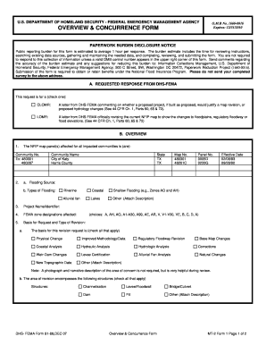
The COASTAL ANALYSIS FORM Floodmaps Fema is a document used to assess flood risk in coastal areas of the United States. This form is essential for property owners, developers, and local governments to understand flood zones and the potential impact of flooding on properties. By analyzing data from FEMA (Federal Emergency Management Agency), the form helps determine flood insurance requirements and informs land-use planning decisions. It is a vital tool for ensuring safety and compliance with federal regulations regarding floodplain management.
How to use the COASTAL ANALYSIS FORM Floodmaps Fema
Using the COASTAL ANALYSIS FORM Floodmaps Fema involves several steps to ensure accurate completion and submission. First, gather all necessary information about the property, including location, elevation, and existing flood zone designations. Next, consult FEMA flood maps to identify the relevant flood zones and any associated risks. Complete the form by providing detailed information as required, ensuring that all sections are filled out accurately. Once completed, the form can be submitted to the appropriate local authorities or agencies for review and processing.
Steps to complete the COASTAL ANALYSIS FORM Floodmaps Fema
Completing the COASTAL ANALYSIS FORM Floodmaps Fema requires careful attention to detail. Follow these steps:
- Obtain the latest version of the form from FEMA or your local government office.
- Review the instructions carefully to understand the requirements.
- Gather necessary documents, including property deeds and previous flood zone determinations.
- Fill out the form with accurate information about the property, including its location and elevation.
- Double-check all entries for accuracy before submission.
- Submit the completed form to the designated local authority or agency.
Key elements of the COASTAL ANALYSIS FORM Floodmaps Fema
The COASTAL ANALYSIS FORM Floodmaps Fema includes several key elements that are crucial for accurate flood risk assessment. These elements typically consist of:
- Property Information: Details about the property location, including address and parcel number.
- Flood Zone Designation: Identification of the flood zone in which the property is located.
- Elevation Data: Information regarding the elevation of the property relative to the base flood elevation.
- Owner Information: Details about the property owner, including contact information.
Legal use of the COASTAL ANALYSIS FORM Floodmaps Fema
The COASTAL ANALYSIS FORM Floodmaps Fema is legally significant as it supports compliance with federal and state floodplain management regulations. Proper use of this form can help property owners secure necessary flood insurance and avoid penalties for non-compliance. Additionally, local governments may require this form during the permitting process for new construction or renovations in flood-prone areas. Understanding the legal implications of the form is essential for ensuring adherence to applicable laws and regulations.
Examples of using the COASTAL ANALYSIS FORM Floodmaps Fema
There are various scenarios where the COASTAL ANALYSIS FORM Floodmaps Fema is utilized. For instance:
- A homeowner seeking to build a new structure in a coastal area may need to complete the form to determine flood risk and insurance requirements.
- A developer planning a residential project in a flood zone must submit the form to comply with local zoning laws.
- A local government may use the form to assess flood risks in a community-wide flood mitigation plan.
Quick guide on how to complete coastal analysis form floodmaps fema
Prepare [SKS] seamlessly on any device
Web-based document management has grown increasingly favored by both businesses and individuals. It offers an ideal eco-friendly alternative to traditional printed and signed papers, as you can acquire the necessary form and safely archive it online. airSlate SignNow equips you with all the resources needed to generate, alter, and electronically sign your documents swiftly without delays. Manage [SKS] on any device using airSlate SignNow's Android or iOS applications and enhance any document-centric task today.
The easiest way to alter and eSign [SKS] effortlessly
- Locate [SKS] and select Get Form to begin.
- Make use of the tools we offer to complete your form.
- Emphasize key sections of the documents or obscure sensitive information with the tools that airSlate SignNow specifically provides for that purpose.
- Create your signature using the Sign tool, which takes seconds and has the same legal validity as a conventional wet ink signature.
- Review all the details and click on the Done button to save your changes.
- Choose how you wish to send your form, via email, text message (SMS), or invitation link, or download it to your computer.
Forget about lost or mislaid documents, tedious form hunts, or errors that necessitate printing new document copies. airSlate SignNow fulfills all your document management needs in just a few clicks from any device you prefer. Alter and eSign [SKS] and ensure excellent communication at every stage of the form preparation process with airSlate SignNow.
Create this form in 5 minutes or less
Related searches to COASTAL ANALYSIS FORM Floodmaps Fema
Create this form in 5 minutes!
How to create an eSignature for the coastal analysis form floodmaps fema
How to create an electronic signature for a PDF online
How to create an electronic signature for a PDF in Google Chrome
How to create an e-signature for signing PDFs in Gmail
How to create an e-signature right from your smartphone
How to create an e-signature for a PDF on iOS
How to create an e-signature for a PDF on Android
People also ask
-
What is the COASTAL ANALYSIS FORM Floodmaps Fema?
The COASTAL ANALYSIS FORM Floodmaps Fema is a crucial document used for assessing flood risks in coastal areas. This form helps individuals and businesses understand floodplain management requirements as outlined by FEMA. It's essential for ensuring compliance with federal regulations while securing properties in flood-prone regions.
-
How can airSlate SignNow assist with the COASTAL ANALYSIS FORM Floodmaps Fema?
airSlate SignNow provides a user-friendly platform to fill out and eSign the COASTAL ANALYSIS FORM Floodmaps Fema efficiently. Our software streamlines the document workflow, allowing you to complete the form quickly and securely. You can share it with stakeholders and track its status in real-time, enhancing your productivity.
-
What are the pricing options for using airSlate SignNow for the COASTAL ANALYSIS FORM Floodmaps Fema?
airSlate SignNow offers flexible pricing plans tailored to your needs, whether you're an individual or part of a large organization. Our pricing is designed to be cost-effective, ensuring that you have access to essential tools for handling the COASTAL ANALYSIS FORM Floodmaps Fema without breaking the bank. Visit our pricing page for detailed options.
-
What features does airSlate SignNow offer for the COASTAL ANALYSIS FORM Floodmaps Fema?
Our platform includes features such as eSignature, document templates, and a secure cloud environment, all beneficial for completing the COASTAL ANALYSIS FORM Floodmaps Fema. Additionally, we provide integration with various CRM and productivity tools to enhance your workflow. This signNowly reduces the time spent on paperwork while maintaining compliance.
-
Can I integrate airSlate SignNow with other tools for managing the COASTAL ANALYSIS FORM Floodmaps Fema?
Yes, airSlate SignNow offers seamless integrations with popular software tools like Google Drive, Salesforce, and more. This allows you to manage the COASTAL ANALYSIS FORM Floodmaps Fema alongside your existing applications, streamlining your processes. You can easily import and export documents, ensuring a smooth workflow across platforms.
-
What benefits does using airSlate SignNow provide for handling the COASTAL ANALYSIS FORM Floodmaps Fema?
Using airSlate SignNow to handle the COASTAL ANALYSIS FORM Floodmaps Fema simplifies the entire process, making it faster and more efficient. You gain access to a secure, reliable platform that enhances collaboration and document management. This not only saves time but also helps mitigate risks associated with incomplete documentation.
-
Is airSlate SignNow secure for handling sensitive information in the COASTAL ANALYSIS FORM Floodmaps Fema?
Absolutely! airSlate SignNow prioritizes security, ensuring that all documents, including the COASTAL ANALYSIS FORM Floodmaps Fema, are protected with advanced encryption and compliance protocols. Our platform adheres to industry standards to safeguard your information, so you can trust us for all your sensitive documentation needs.
Get more for COASTAL ANALYSIS FORM Floodmaps Fema
- Same department new look forms and instructionsform
- Working family creditminnesota department of revenueworking family creditminnesota department of revenueminnesota form m1wfc
- Printable minnesota form m11l insurance premium tax return for life and
- Minnesota form m1c other nonrefundable credits onscreen version
- 2022 m1cd child and dependent care credit m1cd child and dependent care credit form
- 2022 m1lti long term care insurance credit long term care insurance credit form
- Minnesota form m1r age 65 or olderdisabled subtractionprintable 2020 minnesota form m1r age 65 or olderprintable 2020 minnesota
- 2022 m15np additional charge for underpayment of estimated tax form
Find out other COASTAL ANALYSIS FORM Floodmaps Fema
- Can I eSign Kentucky Lawers Document
- How Can I eSign Kentucky Lawers Document
- Can I eSign Kentucky Lawers Document
- How To eSign Kentucky Lawers Form
- How Do I eSign Kentucky Lawers Form
- How To eSign Kentucky Lawers Form
- Help Me With eSign Kentucky Lawers Form
- How Can I eSign Kentucky Lawers Form
- How To eSign Kentucky Lawers Form
- Can I eSign Kentucky Lawers Form
- How Do I eSign Kentucky Lawers Form
- How Do I eSign Kentucky Lawers Form
- How To eSign Kentucky Lawers Form
- Help Me With eSign Kentucky Lawers Form
- Help Me With eSign Kentucky Lawers Form
- How Do I eSign Kentucky Lawers Form
- How Can I eSign Kentucky Lawers Form
- Help Me With eSign Kentucky Lawers Form
- How Can I eSign Kentucky Lawers Form
- Can I eSign Kentucky Lawers Form